You are here: Home > Network List > CI - Caltech Regional Seismic Network Stations List
> Station VTV Victorville, California, USA > Earthquake Result Viewer
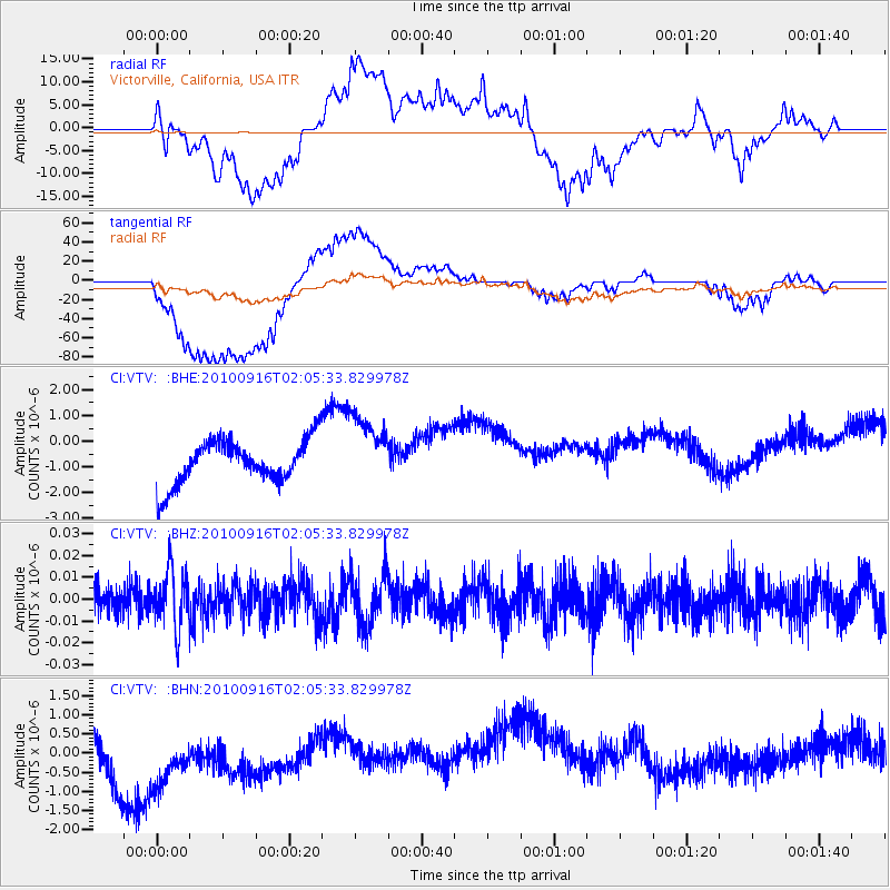
VTV Victorville, California, USA - Earthquake Result Viewer
*The percent match for this event was below the threshold and hence no stack was calculated.
| Earthquake location: |
Tonga Islands |
| Earthquake latitude/longitude: |
-16.0/-174.0 |
| Earthquake time(UTC): |
2010/09/16 (259) 01:54:40 GMT |
| Earthquake Depth: |
84 km |
| Earthquake Magnitude: |
5.5 MB, 5.8 MW, 5.8 MW |
| Earthquake Catalog/Contributor: |
WHDF/NEIC |
|
| Network: |
CI Caltech Regional Seismic Network |
| Station: |
VTV Victorville, California, USA |
| Lat/Lon: |
34.56 N/117.33 W |
| Elevation: |
812 m |
|
| Distance: |
73.6 deg |
| Az: |
45.914 deg |
| Baz: |
236.817 deg |
| Ray Param: |
$rayparam |
*The percent match for this event was below the threshold and hence was not used in the summary stack. |
|
| Radial Match: |
32.71762 % |
| Radial Bump: |
400 |
| Transverse Match: |
53.197594 % |
| Transverse Bump: |
400 |
| SOD ConfigId: |
319893 |
| Insert Time: |
2011-01-20 09:27:49.105 +0000 |
| GWidth: |
2.5 |
| Max Bumps: |
400 |
| Tol: |
0.001 |
|
Signal To Noise
| Channel | StoN | STA | LTA |
| CI:VTV: :BHZ:20100916T02:05:33.829978Z | 2.0831282 | 1.2549342E-8 | 6.024277E-9 |
| CI:VTV: :BHN:20100916T02:05:33.829978Z | 1.7492195 | 1.2769583E-6 | 7.3001604E-7 |
| CI:VTV: :BHE:20100916T02:05:33.829978Z | 1.6506795 | 1.4115016E-6 | 8.5510334E-7 |
| Arrivals |
| Ps | |
| PpPs | |
| PsPs/PpSs | |


