You are here: Home > Network List > IW - Intermountain West Stations List
> Station DLMT Dillon, Montana, USA > Earthquake Result Viewer
DLMT Dillon, Montana, USA - Earthquake Result Viewer
*The percent match for this event was below the threshold and hence no stack was calculated.
| Earthquake location: |
Tonga Islands |
| Earthquake latitude/longitude: |
-16.0/-174.0 |
| Earthquake time(UTC): |
2010/09/16 (259) 01:54:40 GMT |
| Earthquake Depth: |
84 km |
| Earthquake Magnitude: |
5.5 MB, 5.8 MW, 5.8 MW |
| Earthquake Catalog/Contributor: |
WHDF/NEIC |
|
| Network: |
IW Intermountain West |
| Station: |
DLMT Dillon, Montana, USA |
| Lat/Lon: |
45.36 N/112.60 W |
| Elevation: |
1569 m |
|
| Distance: |
82.5 deg |
| Az: |
38.615 deg |
| Baz: |
238.346 deg |
| Ray Param: |
$rayparam |
*The percent match for this event was below the threshold and hence was not used in the summary stack. |
|
| Radial Match: |
52.493095 % |
| Radial Bump: |
400 |
| Transverse Match: |
62.90219 % |
| Transverse Bump: |
400 |
| SOD ConfigId: |
319893 |
| Insert Time: |
2011-01-20 09:31:23.048 +0000 |
| GWidth: |
2.5 |
| Max Bumps: |
400 |
| Tol: |
0.001 |
|
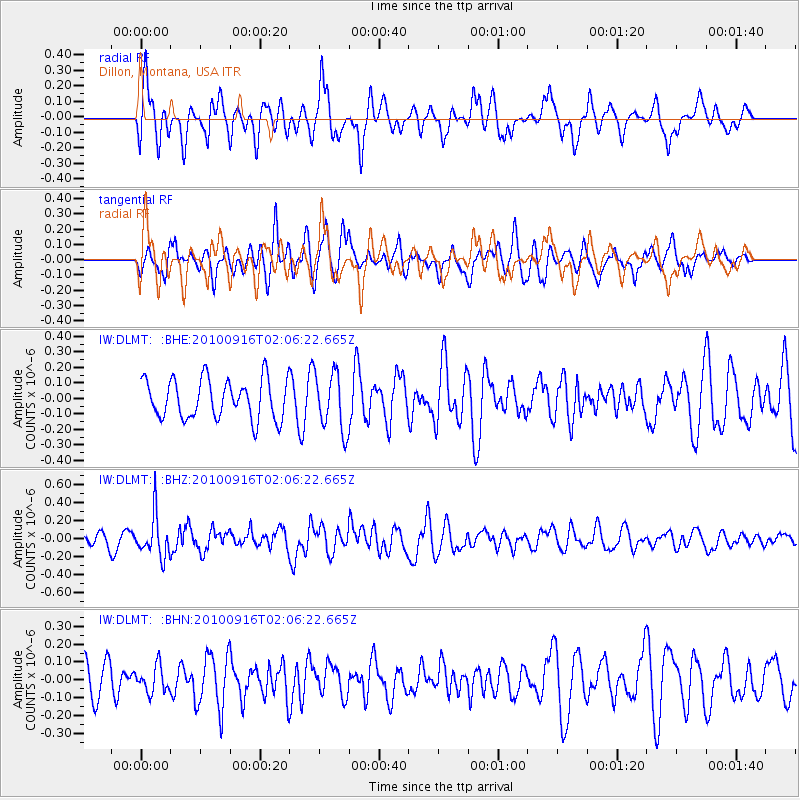
Signal To Noise
| Channel | StoN | STA | LTA |
| IW:DLMT: :BHZ:20100916T02:06:22.665Z | 3.799046 | 2.3369465E-7 | 6.151404E-8 |
| IW:DLMT: :BHN:20100916T02:06:22.665Z | 0.625416 | 7.303015E-8 | 1.1677052E-7 |
| IW:DLMT: :BHE:20100916T02:06:22.665Z | 1.4727658 | 1.8673234E-7 | 1.2679024E-7 |
| Arrivals |
| Ps | |
| PpPs | |
| PsPs/PpSs | |


