You are here: Home > Network List > XG92 - Rocky Mountain Front Stations List
> Station DBQ De Beque, CO > Earthquake Result Viewer
DBQ De Beque, CO - Earthquake Result Viewer
| Earthquake location: |
Svalbard Region |
| Earthquake latitude/longitude: |
76.2/7.2 |
| Earthquake time(UTC): |
1992/09/09 (253) 13:08:54 GMT |
| Earthquake Depth: |
24 km |
| Earthquake Magnitude: |
5.7 MB, 5.6 MS |
| Earthquake Catalog/Contributor: |
WHDF/NEIC |
|
| Network: |
XG Rocky Mountain Front |
| Station: |
DBQ De Beque, CO |
| Lat/Lon: |
39.25 N/108.18 W |
| Elevation: |
1693 m |
|
| Distance: |
57.9 deg |
| Az: |
304.094 deg |
| Baz: |
14.828 deg |
| Ray Param: |
0.063175134 |
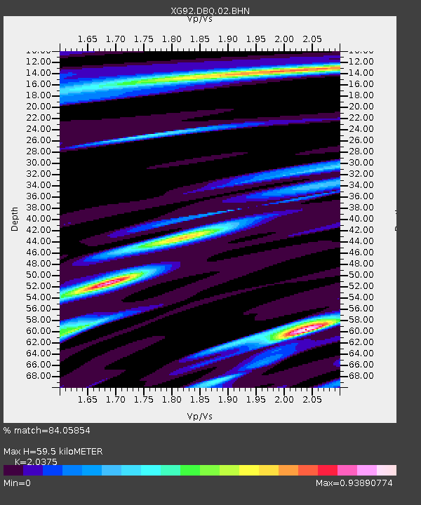
| Estimated Moho Depth: |
59.5 km |
| Estimated Crust Vp/Vs: |
2.04 |
| Assumed Crust Vp: |
6.291 km/s |
| Estimated Crust Vs: |
3.087 km/s |
| Estimated Crust Poisson's Ratio: |
0.34 |
|
| Radial Match: |
84.05854 % |
| Radial Bump: |
400 |
| Transverse Match: |
84.62265 % |
| Transverse Bump: |
400 |
| SOD ConfigId: |
3286 |
| Insert Time: |
2010-02-25 20:08:19.831 +0000 |
| GWidth: |
2.5 |
| Max Bumps: |
400 |
| Tol: |
0.001 |
|

Signal To Noise
| Channel | StoN | STA | LTA |
| XG:DBQ:02:BHN:19920909T13:18:13.572009Z | 1.8676634 | 2.612088E-4 | 1.398586E-4 |
| XG:DBQ:02:BHE:19920909T13:18:13.572009Z | 1.3782523 | 1.4661941E-4 | 1.0638067E-4 |
| XG:DBQ:02:BHZ:19920909T13:18:13.572009Z | 6.954257 | 9.3740196E-4 | 1.3479542E-4 |
| Arrivals |
| Ps | 10 SECOND |
| PpPs | 28 SECOND |
| PsPs/PpSs | 38 SECOND |


