You are here: Home > Network List > TA - USArray Transportable Network (new EarthScope stations) Stations List
> Station N23A Red Feather Lakes, CO, USA > Earthquake Result Viewer
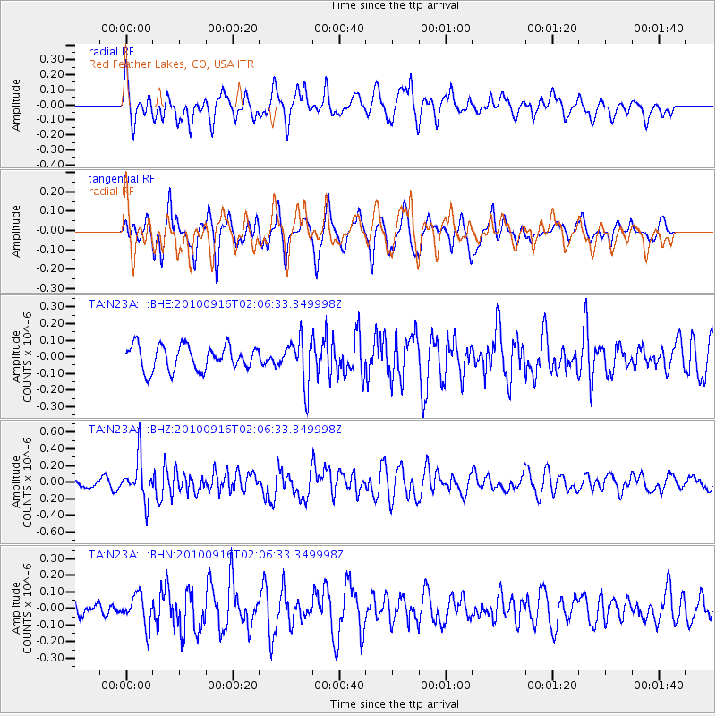
N23A Red Feather Lakes, CO, USA - Earthquake Result Viewer
*The percent match for this event was below the threshold and hence no stack was calculated.
| Earthquake location: |
Tonga Islands |
| Earthquake latitude/longitude: |
-16.0/-174.0 |
| Earthquake time(UTC): |
2010/09/16 (259) 01:54:40 GMT |
| Earthquake Depth: |
84 km |
| Earthquake Magnitude: |
5.5 MB, 5.8 MW, 5.8 MW |
| Earthquake Catalog/Contributor: |
WHDF/NEIC |
|
| Network: |
TA USArray Transportable Network (new EarthScope stations) |
| Station: |
N23A Red Feather Lakes, CO, USA |
| Lat/Lon: |
40.89 N/105.94 W |
| Elevation: |
2458 m |
|
| Distance: |
84.6 deg |
| Az: |
44.917 deg |
| Baz: |
243.591 deg |
| Ray Param: |
$rayparam |
*The percent match for this event was below the threshold and hence was not used in the summary stack. |
|
| Radial Match: |
55.160213 % |
| Radial Bump: |
400 |
| Transverse Match: |
45.772114 % |
| Transverse Bump: |
369 |
| SOD ConfigId: |
319893 |
| Insert Time: |
2011-01-20 09:33:41.054 +0000 |
| GWidth: |
2.5 |
| Max Bumps: |
400 |
| Tol: |
0.001 |
|
Signal To Noise
| Channel | StoN | STA | LTA |
| TA:N23A: :BHZ:20100916T02:06:33.349998Z | 3.9516363 | 2.5079765E-7 | 6.3466786E-8 |
| TA:N23A: :BHN:20100916T02:06:33.349998Z | 1.4287908 | 9.564513E-8 | 6.694131E-8 |
| TA:N23A: :BHE:20100916T02:06:33.349998Z | 1.8333423 | 1.3575072E-7 | 7.404548E-8 |
| Arrivals |
| Ps | |
| PpPs | |
| PsPs/PpSs | |


