You are here: Home > Network List > TA - USArray Transportable Network (new EarthScope stations) Stations List
> Station 331A San Angelo, TX, USA > Earthquake Result Viewer
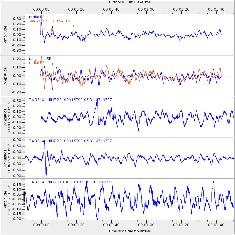
331A San Angelo, TX, USA - Earthquake Result Viewer
*The percent match for this event was below the threshold and hence no stack was calculated.
| Earthquake location: |
Tonga Islands |
| Earthquake latitude/longitude: |
-16.0/-174.0 |
| Earthquake time(UTC): |
2010/09/16 (259) 01:54:40 GMT |
| Earthquake Depth: |
84 km |
| Earthquake Magnitude: |
5.5 MB, 5.8 MW, 5.8 MW |
| Earthquake Catalog/Contributor: |
WHDF/NEIC |
|
| Network: |
TA USArray Transportable Network (new EarthScope stations) |
| Station: |
331A San Angelo, TX, USA |
| Lat/Lon: |
31.31 N/100.43 W |
| Elevation: |
615 m |
|
| Distance: |
84.8 deg |
| Az: |
55.514 deg |
| Baz: |
247.825 deg |
| Ray Param: |
$rayparam |
*The percent match for this event was below the threshold and hence was not used in the summary stack. |
|
| Radial Match: |
49.04465 % |
| Radial Bump: |
400 |
| Transverse Match: |
65.22407 % |
| Transverse Bump: |
400 |
| SOD ConfigId: |
319893 |
| Insert Time: |
2011-01-20 09:37:19.696 +0000 |
| GWidth: |
2.5 |
| Max Bumps: |
400 |
| Tol: |
0.001 |
|
Signal To Noise
| Channel | StoN | STA | LTA |
| TA:331A: :BHZ:20100916T02:06:34.074973Z | 5.1427627 | 3.875617E-7 | 7.53606E-8 |
| TA:331A: :BHN:20100916T02:06:34.074973Z | 0.96222764 | 4.051314E-8 | 4.2103487E-8 |
| TA:331A: :BHE:20100916T02:06:34.074973Z | 3.2454488 | 1.5033213E-7 | 4.6320903E-8 |
| Arrivals |
| Ps | |
| PpPs | |
| PsPs/PpSs | |


