You are here: Home > Network List > TA - USArray Transportable Network (new EarthScope stations) Stations List
> Station 130A Snyder, TX, USA > Earthquake Result Viewer
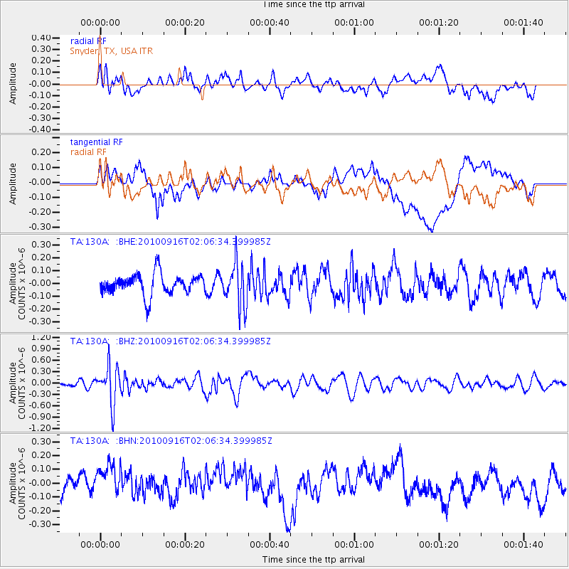
130A Snyder, TX, USA - Earthquake Result Viewer
*The percent match for this event was below the threshold and hence no stack was calculated.
| Earthquake location: |
Tonga Islands |
| Earthquake latitude/longitude: |
-16.0/-174.0 |
| Earthquake time(UTC): |
2010/09/16 (259) 01:54:40 GMT |
| Earthquake Depth: |
84 km |
| Earthquake Magnitude: |
5.5 MB, 5.8 MW, 5.8 MW |
| Earthquake Catalog/Contributor: |
WHDF/NEIC |
|
| Network: |
TA USArray Transportable Network (new EarthScope stations) |
| Station: |
130A Snyder, TX, USA |
| Lat/Lon: |
32.60 N/100.97 W |
| Elevation: |
676 m |
|
| Distance: |
84.8 deg |
| Az: |
54.147 deg |
| Baz: |
247.417 deg |
| Ray Param: |
$rayparam |
*The percent match for this event was below the threshold and hence was not used in the summary stack. |
|
| Radial Match: |
61.078476 % |
| Radial Bump: |
400 |
| Transverse Match: |
55.09571 % |
| Transverse Bump: |
400 |
| SOD ConfigId: |
319893 |
| Insert Time: |
2011-01-20 09:38:05.976 +0000 |
| GWidth: |
2.5 |
| Max Bumps: |
400 |
| Tol: |
0.001 |
|
Signal To Noise
| Channel | StoN | STA | LTA |
| TA:130A: :BHZ:20100916T02:06:34.399985Z | 6.4535275 | 5.0780903E-7 | 7.868705E-8 |
| TA:130A: :BHN:20100916T02:06:34.399985Z | 1.2767016 | 1.16579024E-7 | 9.1312664E-8 |
| TA:130A: :BHE:20100916T02:06:34.399985Z | 2.1401477 | 1.7315378E-7 | 8.090739E-8 |
| Arrivals |
| Ps | |
| PpPs | |
| PsPs/PpSs | |


