You are here: Home > Network List > TA - USArray Transportable Network (new EarthScope stations) Stations List
> Station T30A Plains, KS, USA > Earthquake Result Viewer
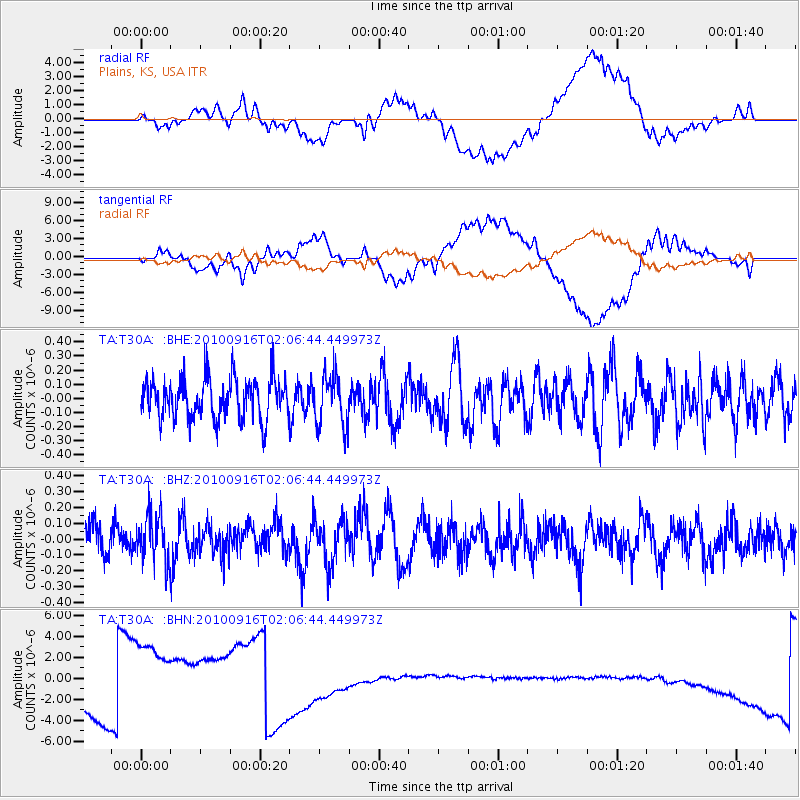
T30A Plains, KS, USA - Earthquake Result Viewer
*The percent match for this event was below the threshold and hence no stack was calculated.
| Earthquake location: |
Tonga Islands |
| Earthquake latitude/longitude: |
-16.0/-174.0 |
| Earthquake time(UTC): |
2010/09/16 (259) 01:54:40 GMT |
| Earthquake Depth: |
84 km |
| Earthquake Magnitude: |
5.5 MB, 5.8 MW, 5.8 MW |
| Earthquake Catalog/Contributor: |
WHDF/NEIC |
|
| Network: |
TA USArray Transportable Network (new EarthScope stations) |
| Station: |
T30A Plains, KS, USA |
| Lat/Lon: |
37.05 N/100.53 W |
| Elevation: |
778 m |
|
| Distance: |
86.9 deg |
| Az: |
50.171 deg |
| Baz: |
247.378 deg |
| Ray Param: |
$rayparam |
*The percent match for this event was below the threshold and hence was not used in the summary stack. |
|
| Radial Match: |
42.77761 % |
| Radial Bump: |
400 |
| Transverse Match: |
43.332962 % |
| Transverse Bump: |
400 |
| SOD ConfigId: |
319893 |
| Insert Time: |
2011-01-20 09:38:54.910 +0000 |
| GWidth: |
2.5 |
| Max Bumps: |
400 |
| Tol: |
0.001 |
|
Signal To Noise
| Channel | StoN | STA | LTA |
| TA:T30A: :BHZ:20100916T02:06:44.449973Z | 1.3893161 | 1.4826728E-7 | 1.0671961E-7 |
| TA:T30A: :BHN:20100916T02:06:44.449973Z | 3.4522333 | 4.434277E-6 | 1.2844662E-6 |
| TA:T30A: :BHE:20100916T02:06:44.449973Z | 1.2724847 | 1.7669772E-7 | 1.3886039E-7 |
| Arrivals |
| Ps | |
| PpPs | |
| PsPs/PpSs | |


