You are here: Home > Network List > MM - Myanmar National Seismic Network Stations List
> Station NGU Ngaung U, Myanmar > Earthquake Result Viewer
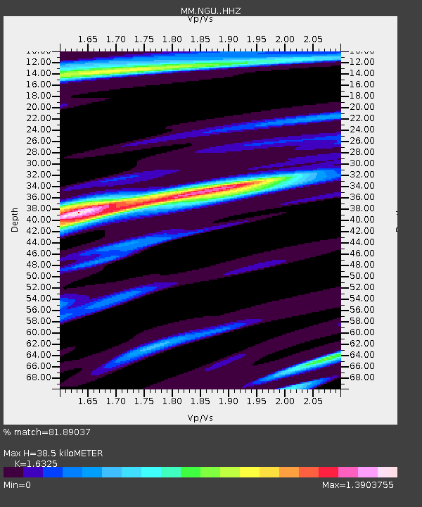
NGU Ngaung U, Myanmar - Earthquake Result Viewer
| Earthquake location: |
Near East Coast Of Honshu, Japan |
| Earthquake latitude/longitude: |
37.1/141.1 |
| Earthquake time(UTC): |
2024/03/14 (074) 15:14:36 GMT |
| Earthquake Depth: |
53 km |
| Earthquake Magnitude: |
5.6 mww |
| Earthquake Catalog/Contributor: |
NEIC PDE/us |
|
| Network: |
MM Myanmar National Seismic Network |
| Station: |
NGU Ngaung U, Myanmar |
| Lat/Lon: |
21.21 N/94.92 E |
| Elevation: |
70 m |
|
| Distance: |
42.9 deg |
| Az: |
261.537 deg |
| Baz: |
57.938 deg |
| Ray Param: |
0.07272629 |
| Estimated Moho Depth: |
38.5 km |
| Estimated Crust Vp/Vs: |
1.63 |
| Assumed Crust Vp: |
6.036 km/s |
| Estimated Crust Vs: |
3.698 km/s |
| Estimated Crust Poisson's Ratio: |
0.20 |
|
| Radial Match: |
81.89037 % |
| Radial Bump: |
400 |
| Transverse Match: |
67.18013 % |
| Transverse Bump: |
400 |
| SOD ConfigId: |
33437571 |
| Insert Time: |
2024-03-28 15:32:15.944 +0000 |
| GWidth: |
2.5 |
| Max Bumps: |
400 |
| Tol: |
0.001 |
|

Signal To Noise
| Channel | StoN | STA | LTA |
| MM:NGU: :HHZ:20240314T15:21:59.809998Z | 13.2909775 | 2.1088103E-6 | 1.586648E-7 |
| MM:NGU: :HHN:20240314T15:21:59.809998Z | 2.0811658 | 3.6896049E-7 | 1.7728547E-7 |
| MM:NGU: :HHE:20240314T15:21:59.809998Z | 3.0633287 | 5.6521463E-7 | 1.8450996E-7 |
| Arrivals |
| Ps | 4.3 SECOND |
| PpPs | 16 SECOND |
| PsPs/PpSs | 20 SECOND |


