You are here: Home > Network List > TA - USArray Transportable Network (new EarthScope stations) Stations List
> Station 535A Dale, TX, USA > Earthquake Result Viewer
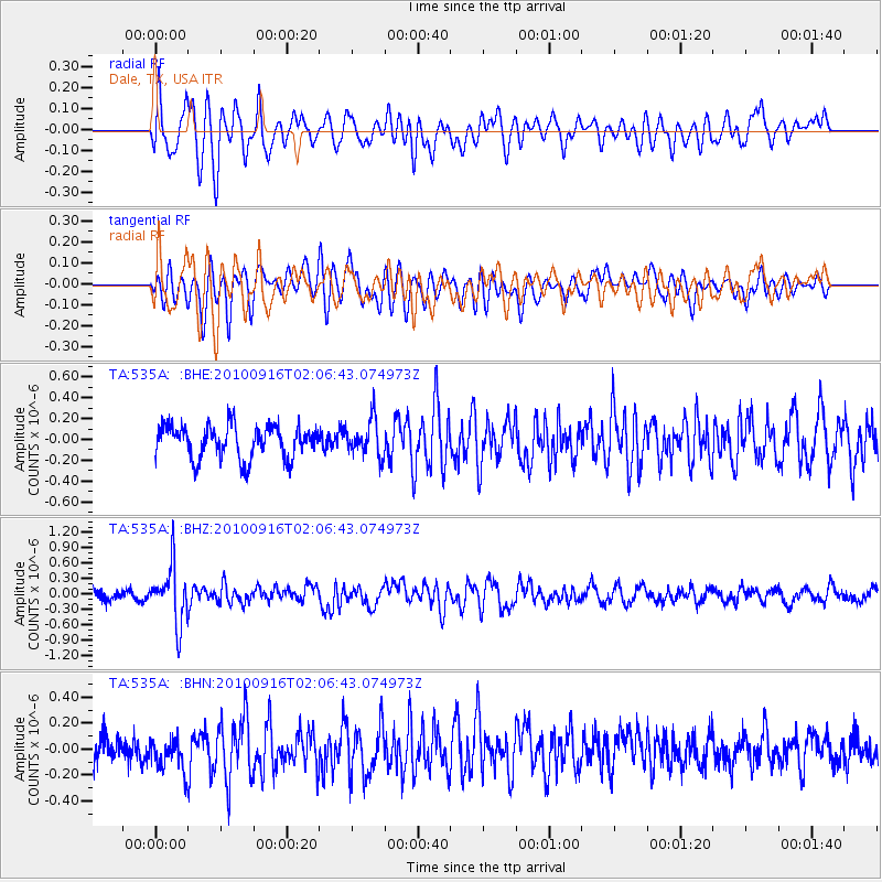
535A Dale, TX, USA - Earthquake Result Viewer
*The percent match for this event was below the threshold and hence no stack was calculated.
| Earthquake location: |
Tonga Islands |
| Earthquake latitude/longitude: |
-16.0/-174.0 |
| Earthquake time(UTC): |
2010/09/16 (259) 01:54:40 GMT |
| Earthquake Depth: |
84 km |
| Earthquake Magnitude: |
5.5 MB, 5.8 MW, 5.8 MW |
| Earthquake Catalog/Contributor: |
WHDF/NEIC |
|
| Network: |
TA USArray Transportable Network (new EarthScope stations) |
| Station: |
535A Dale, TX, USA |
| Lat/Lon: |
30.03 N/97.57 W |
| Elevation: |
170 m |
|
| Distance: |
86.6 deg |
| Az: |
57.604 deg |
| Baz: |
249.433 deg |
| Ray Param: |
$rayparam |
*The percent match for this event was below the threshold and hence was not used in the summary stack. |
|
| Radial Match: |
64.96674 % |
| Radial Bump: |
400 |
| Transverse Match: |
62.483173 % |
| Transverse Bump: |
400 |
| SOD ConfigId: |
319893 |
| Insert Time: |
2011-01-20 09:44:16.584 +0000 |
| GWidth: |
2.5 |
| Max Bumps: |
400 |
| Tol: |
0.001 |
|
Signal To Noise
| Channel | StoN | STA | LTA |
| TA:535A: :BHZ:20100916T02:06:43.074973Z | 6.0315957 | 5.4666566E-7 | 9.063367E-8 |
| TA:535A: :BHN:20100916T02:06:43.074973Z | 1.123738 | 1.2760178E-7 | 1.1355118E-7 |
| TA:535A: :BHE:20100916T02:06:43.074973Z | 1.108897 | 1.7528315E-7 | 1.5806981E-7 |
| Arrivals |
| Ps | |
| PpPs | |
| PsPs/PpSs | |


