You are here: Home > Network List > AG - Arkansas Seismic Network Stations List
> Station XA02 Annieville, Arkansas > Earthquake Result Viewer
XA02 Annieville, Arkansas - Earthquake Result Viewer
| Earthquake location: |
Northern Mid-Atlantic Ridge |
| Earthquake latitude/longitude: |
29.8/-42.7 |
| Earthquake time(UTC): |
2024/03/14 (074) 21:10:25 GMT |
| Earthquake Depth: |
10 km |
| Earthquake Magnitude: |
6.0 mww |
| Earthquake Catalog/Contributor: |
NEIC PDE/us |
|
| Network: |
AG Arkansas Seismic Network |
| Station: |
XA02 Annieville, Arkansas |
| Lat/Lon: |
36.16 N/91.26 W |
| Elevation: |
190 m |
|
| Distance: |
40.9 deg |
| Az: |
292.029 deg |
| Baz: |
84.487 deg |
| Ray Param: |
0.07412529 |
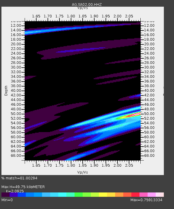
| Estimated Moho Depth: |
49.75 km |
| Estimated Crust Vp/Vs: |
2.09 |
| Assumed Crust Vp: |
6.53 km/s |
| Estimated Crust Vs: |
3.121 km/s |
| Estimated Crust Poisson's Ratio: |
0.35 |
|
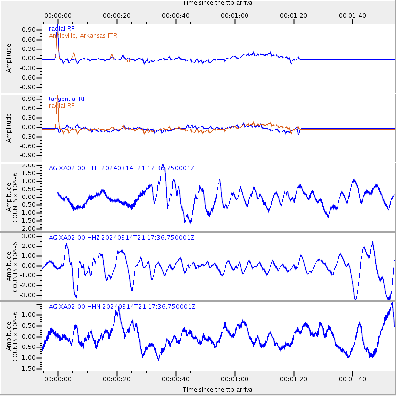
| Radial Match: |
81.80294 % |
| Radial Bump: |
390 |
| Transverse Match: |
59.673325 % |
| Transverse Bump: |
400 |
| SOD ConfigId: |
33437571 |
| Insert Time: |
2024-03-28 21:13:45.471 +0000 |
| GWidth: |
2.5 |
| Max Bumps: |
400 |
| Tol: |
0.001 |
|
Signal To Noise
| Channel | StoN | STA | LTA |
| AG:XA02:00:HHZ:20240314T21:17:36.750001Z | 3.8214455 | 1.0271345E-6 | 2.687817E-7 |
| AG:XA02:00:HHN:20240314T21:17:36.750001Z | 0.3510065 | 1.3755472E-7 | 3.9188654E-7 |
| AG:XA02:00:HHE:20240314T21:17:36.750001Z | 2.36552 | 7.459488E-7 | 3.153424E-7 |
| Arrivals |
| Ps | 8.8 SECOND |
| PpPs | 22 SECOND |
| PsPs/PpSs | 31 SECOND |


