You are here: Home > Network List > AG - Arkansas Seismic Network Stations List
> Station XB03 El Dorado Temporary Station XB03 > Earthquake Result Viewer
XB03 El Dorado Temporary Station XB03 - Earthquake Result Viewer

| Earthquake location: |
Northern Mid-Atlantic Ridge |
| Earthquake latitude/longitude: |
29.8/-42.7 |
| Earthquake time(UTC): |
2024/03/14 (074) 21:10:25 GMT |
| Earthquake Depth: |
10 km |
| Earthquake Magnitude: |
6.0 mww |
| Earthquake Catalog/Contributor: |
NEIC PDE/us |
|
| Network: |
AG Arkansas Seismic Network |
| Station: |
XB03 El Dorado Temporary Station XB03 |
| Lat/Lon: |
36.48 N/90.87 W |
| Elevation: |
144 m |
|
| Distance: |
40.6 deg |
| Az: |
292.469 deg |
| Baz: |
85.051 deg |
| Ray Param: |
0.0743316 |
| Estimated Moho Depth: |
58.75 km |
| Estimated Crust Vp/Vs: |
1.60 |
| Assumed Crust Vp: |
6.53 km/s |
| Estimated Crust Vs: |
4.082 km/s |
| Estimated Crust Poisson's Ratio: |
0.18 |
|
| Radial Match: |
81.35982 % |
| Radial Bump: |
400 |
| Transverse Match: |
38.45077 % |
| Transverse Bump: |
400 |
| SOD ConfigId: |
33437571 |
| Insert Time: |
2024-03-28 21:13:48.600 +0000 |
| GWidth: |
2.5 |
| Max Bumps: |
400 |
| Tol: |
0.001 |
|
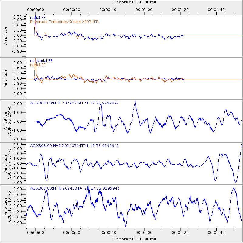
Signal To Noise
| Channel | StoN | STA | LTA |
| AG:XB03:00:HHZ:20240314T21:17:33.929994Z | 6.5276794 | 8.9366466E-7 | 1.3690389E-7 |
| AG:XB03:00:HHN:20240314T21:17:33.929994Z | 1.6457647 | 4.771866E-7 | 2.8994825E-7 |
| AG:XB03:00:HHE:20240314T21:17:33.929994Z | 1.1622177 | 5.7400155E-7 | 4.9388467E-7 |
| Arrivals |
| Ps | 5.9 SECOND |
| PpPs | 22 SECOND |
| PsPs/PpSs | 27 SECOND |


