You are here: Home > Network List > CM - Red Sismologica Nacional de Columbia Stations List
> Station SMAR Santa Marta, Magdalena, Colombia > Earthquake Result Viewer
SMAR Santa Marta, Magdalena, Colombia - Earthquake Result Viewer
| Earthquake location: |
Northern Mid-Atlantic Ridge |
| Earthquake latitude/longitude: |
29.8/-42.7 |
| Earthquake time(UTC): |
2024/03/14 (074) 21:10:25 GMT |
| Earthquake Depth: |
10 km |
| Earthquake Magnitude: |
6.0 mww |
| Earthquake Catalog/Contributor: |
NEIC PDE/us |
|
| Network: |
CM Red Sismologica Nacional de Columbia |
| Station: |
SMAR Santa Marta, Magdalena, Colombia |
| Lat/Lon: |
11.16 N/74.22 W |
| Elevation: |
122 m |
|
| Distance: |
34.7 deg |
| Az: |
244.346 deg |
| Baz: |
52.956 deg |
| Ray Param: |
0.07759515 |
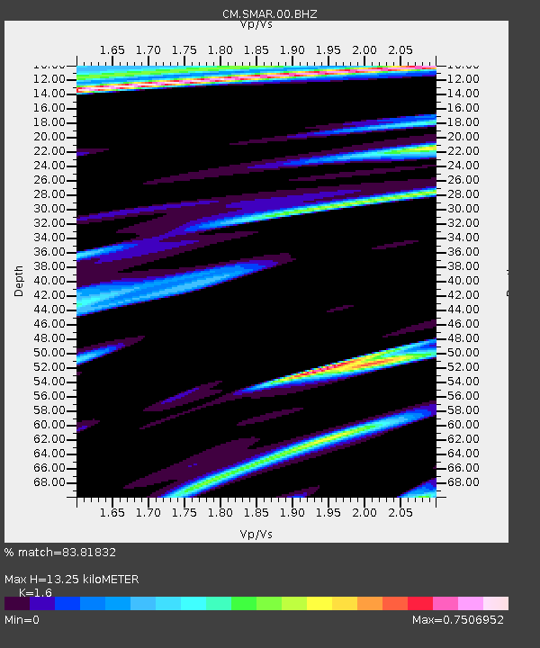
| Estimated Moho Depth: |
13.25 km |
| Estimated Crust Vp/Vs: |
1.60 |
| Assumed Crust Vp: |
5.129 km/s |
| Estimated Crust Vs: |
3.206 km/s |
| Estimated Crust Poisson's Ratio: |
0.18 |
|
| Radial Match: |
83.81832 % |
| Radial Bump: |
400 |
| Transverse Match: |
61.61426 % |
| Transverse Bump: |
400 |
| SOD ConfigId: |
33437571 |
| Insert Time: |
2024-03-28 21:24:57.986 +0000 |
| GWidth: |
2.5 |
| Max Bumps: |
400 |
| Tol: |
0.001 |
|

Signal To Noise
| Channel | StoN | STA | LTA |
| CM:SMAR:00:BHZ:20240314T21:16:44.769014Z | 5.101311 | 8.5993383E-7 | 1.6857113E-7 |
| CM:SMAR:00:BHN:20240314T21:16:44.769014Z | 1.6435983 | 4.987794E-7 | 3.0346794E-7 |
| CM:SMAR:00:BHE:20240314T21:16:44.769014Z | 1.2113595 | 3.232808E-7 | 2.6687437E-7 |
| Arrivals |
| Ps | 1.6 SECOND |
| PpPs | 6.4 SECOND |
| PsPs/PpSs | 8.0 SECOND |


