You are here: Home > Network List > GO - National Seismic Network of Georgia Stations List
> Station KHRT Khreiti, Georgia > Earthquake Result Viewer
KHRT Khreiti, Georgia - Earthquake Result Viewer
| Earthquake location: |
Northern Mid-Atlantic Ridge |
| Earthquake latitude/longitude: |
29.8/-42.7 |
| Earthquake time(UTC): |
2024/03/14 (074) 21:10:25 GMT |
| Earthquake Depth: |
10 km |
| Earthquake Magnitude: |
6.0 mww |
| Earthquake Catalog/Contributor: |
NEIC PDE/us |
|
| Network: |
GO National Seismic Network of Georgia |
| Station: |
KHRT Khreiti, Georgia |
| Lat/Lon: |
42.35 N/43.22 E |
| Elevation: |
1164 m |
|
| Distance: |
67.8 deg |
| Az: |
53.013 deg |
| Baz: |
290.556 deg |
| Ray Param: |
0.0567558 |
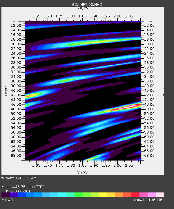
| Estimated Moho Depth: |
46.75 km |
| Estimated Crust Vp/Vs: |
2.05 |
| Assumed Crust Vp: |
6.247 km/s |
| Estimated Crust Vs: |
3.051 km/s |
| Estimated Crust Poisson's Ratio: |
0.34 |
|
| Radial Match: |
83.21975 % |
| Radial Bump: |
324 |
| Transverse Match: |
77.93337 % |
| Transverse Bump: |
350 |
| SOD ConfigId: |
33437571 |
| Insert Time: |
2024-03-28 21:29:27.263 +0000 |
| GWidth: |
2.5 |
| Max Bumps: |
400 |
| Tol: |
0.001 |
|

Signal To Noise
| Channel | StoN | STA | LTA |
| GO:KHRT:00:HHZ:20240314T21:20:51.869997Z | 7.074781 | 7.42788E-7 | 1.0499096E-7 |
| GO:KHRT:00:HHN:20240314T21:20:51.869997Z | 1.1377083 | 2.0365373E-7 | 1.7900345E-7 |
| GO:KHRT:00:HHE:20240314T21:20:51.869997Z | 2.1323001 | 2.5882966E-7 | 1.2138518E-7 |
| Arrivals |
| Ps | 8.1 SECOND |
| PpPs | 22 SECOND |
| PsPs/PpSs | 30 SECOND |


