You are here: Home > Network List > GS - US Geological Survey Networks Stations List
> Station ASA4 ASA4 > Earthquake Result Viewer
ASA4 ASA4 - Earthquake Result Viewer
| Earthquake location: |
Northern Mid-Atlantic Ridge |
| Earthquake latitude/longitude: |
29.8/-42.7 |
| Earthquake time(UTC): |
2024/03/14 (074) 21:10:25 GMT |
| Earthquake Depth: |
10 km |
| Earthquake Magnitude: |
6.0 mww |
| Earthquake Catalog/Contributor: |
NEIC PDE/us |
|
| Network: |
GS US Geological Survey Networks |
| Station: |
ASA4 ASA4 |
| Lat/Lon: |
34.94 N/106.46 W |
| Elevation: |
1820 m |
|
| Distance: |
53.3 deg |
| Az: |
293.199 deg |
| Baz: |
76.451 deg |
| Ray Param: |
0.066193774 |
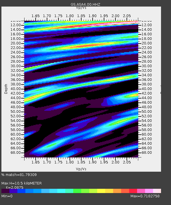
| Estimated Moho Depth: |
10.5 km |
| Estimated Crust Vp/Vs: |
2.09 |
| Assumed Crust Vp: |
6.502 km/s |
| Estimated Crust Vs: |
3.114 km/s |
| Estimated Crust Poisson's Ratio: |
0.35 |
|
| Radial Match: |
81.79309 % |
| Radial Bump: |
376 |
| Transverse Match: |
69.34526 % |
| Transverse Bump: |
373 |
| SOD ConfigId: |
33437571 |
| Insert Time: |
2024-03-28 21:29:52.572 +0000 |
| GWidth: |
2.5 |
| Max Bumps: |
400 |
| Tol: |
0.001 |
|

Signal To Noise
| Channel | StoN | STA | LTA |
| GS:ASA4:00:HHZ:20240314T21:19:13.479005Z | 2.7933648 | 7.46733E-7 | 2.6732386E-7 |
| GS:ASA4:00:HH1:20240314T21:19:13.479005Z | 0.63706386 | 1.05611875E-7 | 1.657791E-7 |
| GS:ASA4:00:HH2:20240314T21:19:13.479005Z | 1.599372 | 3.5209317E-7 | 2.2014463E-7 |
| Arrivals |
| Ps | 1.8 SECOND |
| PpPs | 4.8 SECOND |
| PsPs/PpSs | 6.6 SECOND |


