You are here: Home > Network List > GS - US Geological Survey Networks Stations List
> Station ASA6 ASA6 > Earthquake Result Viewer
ASA6 ASA6 - Earthquake Result Viewer
| Earthquake location: |
Northern Mid-Atlantic Ridge |
| Earthquake latitude/longitude: |
29.8/-42.7 |
| Earthquake time(UTC): |
2024/03/14 (074) 21:10:25 GMT |
| Earthquake Depth: |
10 km |
| Earthquake Magnitude: |
6.0 mww |
| Earthquake Catalog/Contributor: |
NEIC PDE/us |
|
| Network: |
GS US Geological Survey Networks |
| Station: |
ASA6 ASA6 |
| Lat/Lon: |
34.94 N/106.46 W |
| Elevation: |
1840 m |
|
| Distance: |
53.3 deg |
| Az: |
293.199 deg |
| Baz: |
76.455 deg |
| Ray Param: |
0.066197135 |
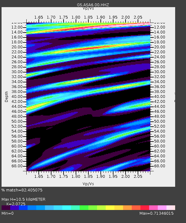
| Estimated Moho Depth: |
10.5 km |
| Estimated Crust Vp/Vs: |
2.07 |
| Assumed Crust Vp: |
6.502 km/s |
| Estimated Crust Vs: |
3.137 km/s |
| Estimated Crust Poisson's Ratio: |
0.35 |
|
| Radial Match: |
82.405075 % |
| Radial Bump: |
355 |
| Transverse Match: |
69.048 % |
| Transverse Bump: |
368 |
| SOD ConfigId: |
33437571 |
| Insert Time: |
2024-03-28 21:29:55.772 +0000 |
| GWidth: |
2.5 |
| Max Bumps: |
400 |
| Tol: |
0.001 |
|

Signal To Noise
| Channel | StoN | STA | LTA |
| GS:ASA6:00:HHZ:20240314T21:19:13.439027Z | 2.792212 | 7.391841E-7 | 2.6473066E-7 |
| GS:ASA6:00:HH1:20240314T21:19:13.439027Z | 0.61636645 | 9.388937E-8 | 1.5232719E-7 |
| GS:ASA6:00:HH2:20240314T21:19:13.439027Z | 1.5681281 | 3.501782E-7 | 2.2330968E-7 |
| Arrivals |
| Ps | 1.8 SECOND |
| PpPs | 4.7 SECOND |
| PsPs/PpSs | 6.5 SECOND |


