You are here: Home > Network List > IE - INL Seismic Monitoring Program Stations List
> Station COMI Craters of the Moon, Idaho, USA > Earthquake Result Viewer
COMI Craters of the Moon, Idaho, USA - Earthquake Result Viewer
| Earthquake location: |
Northern Mid-Atlantic Ridge |
| Earthquake latitude/longitude: |
29.8/-42.7 |
| Earthquake time(UTC): |
2024/03/14 (074) 21:10:25 GMT |
| Earthquake Depth: |
10 km |
| Earthquake Magnitude: |
6.0 mww |
| Earthquake Catalog/Contributor: |
NEIC PDE/us |
|
| Network: |
IE INL Seismic Monitoring Program |
| Station: |
COMI Craters of the Moon, Idaho, USA |
| Lat/Lon: |
43.46 N/113.59 W |
| Elevation: |
1890 m |
|
| Distance: |
56.9 deg |
| Az: |
304.775 deg |
| Baz: |
78.585 deg |
| Ray Param: |
0.06383094 |
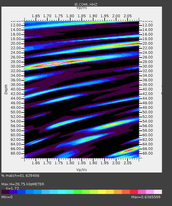
| Estimated Moho Depth: |
28.75 km |
| Estimated Crust Vp/Vs: |
1.72 |
| Assumed Crust Vp: |
6.279 km/s |
| Estimated Crust Vs: |
3.65 km/s |
| Estimated Crust Poisson's Ratio: |
0.24 |
|
| Radial Match: |
81.629486 % |
| Radial Bump: |
332 |
| Transverse Match: |
63.4261 % |
| Transverse Bump: |
400 |
| SOD ConfigId: |
33437571 |
| Insert Time: |
2024-03-28 21:30:38.922 +0000 |
| GWidth: |
2.5 |
| Max Bumps: |
400 |
| Tol: |
0.001 |
|

Signal To Noise
| Channel | StoN | STA | LTA |
| IE:COMI: :HHZ:20240314T21:19:39.367982Z | 4.086584 | 7.1782176E-7 | 1.7565324E-7 |
| IE:COMI: :HHN:20240314T21:19:39.367982Z | 0.63600546 | 1.3401066E-7 | 2.1070679E-7 |
| IE:COMI: :HHE:20240314T21:19:39.367982Z | 2.249406 | 3.5620985E-7 | 1.5835728E-7 |
| Arrivals |
| Ps | 3.5 SECOND |
| PpPs | 12 SECOND |
| PsPs/PpSs | 15 SECOND |


