You are here: Home > Network List > US - United States National Seismic Network Stations List
> Station DGMT Dagmar, Montana, USA > Earthquake Result Viewer
DGMT Dagmar, Montana, USA - Earthquake Result Viewer
*The percent match for this event was below the threshold and hence no stack was calculated.
| Earthquake location: |
Tonga Islands |
| Earthquake latitude/longitude: |
-16.0/-174.0 |
| Earthquake time(UTC): |
2010/09/16 (259) 01:54:40 GMT |
| Earthquake Depth: |
84 km |
| Earthquake Magnitude: |
5.5 MB, 5.8 MW, 5.8 MW |
| Earthquake Catalog/Contributor: |
WHDF/NEIC |
|
| Network: |
US United States National Seismic Network |
| Station: |
DGMT Dagmar, Montana, USA |
| Lat/Lon: |
48.47 N/104.20 W |
| Elevation: |
0.0 m |
|
| Distance: |
89.1 deg |
| Az: |
38.647 deg |
| Baz: |
244.472 deg |
| Ray Param: |
$rayparam |
*The percent match for this event was below the threshold and hence was not used in the summary stack. |
|
| Radial Match: |
57.62553 % |
| Radial Bump: |
391 |
| Transverse Match: |
48.826344 % |
| Transverse Bump: |
400 |
| SOD ConfigId: |
319893 |
| Insert Time: |
2011-01-20 09:52:42.515 +0000 |
| GWidth: |
2.5 |
| Max Bumps: |
400 |
| Tol: |
0.001 |
|
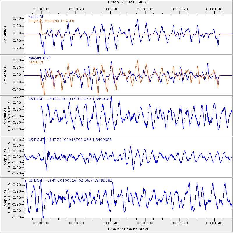
Signal To Noise
| Channel | StoN | STA | LTA |
| US:DGMT: :BHZ:20100916T02:06:54.849998Z | 3.69146 | 3.5417193E-7 | 9.594359E-8 |
| US:DGMT: :BHN:20100916T02:06:54.849998Z | 1.3137041 | 3.2331974E-7 | 2.4611305E-7 |
| US:DGMT: :BHE:20100916T02:06:54.849998Z | 1.2301711 | 2.4747905E-7 | 2.0117452E-7 |
| Arrivals |
| Ps | |
| PpPs | |
| PsPs/PpSs | |


