You are here: Home > Network List > N4 - Central and EAstern US Network Stations List
> Station Q56A Snyder Ridge, Maysville, WV, USA > Earthquake Result Viewer
Q56A Snyder Ridge, Maysville, WV, USA - Earthquake Result Viewer
| Earthquake location: |
Northern Mid-Atlantic Ridge |
| Earthquake latitude/longitude: |
29.8/-42.7 |
| Earthquake time(UTC): |
2024/03/14 (074) 21:10:25 GMT |
| Earthquake Depth: |
10 km |
| Earthquake Magnitude: |
6.0 mww |
| Earthquake Catalog/Contributor: |
NEIC PDE/us |
|
| Network: |
N4 Central and EAstern US Network |
| Station: |
Q56A Snyder Ridge, Maysville, WV, USA |
| Lat/Lon: |
39.04 N/79.19 W |
| Elevation: |
430 m |
|
| Distance: |
31.3 deg |
| Az: |
296.919 deg |
| Baz: |
95.806 deg |
| Ray Param: |
0.07911993 |
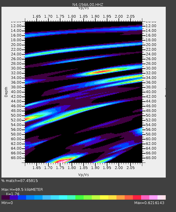
| Estimated Moho Depth: |
69.5 km |
| Estimated Crust Vp/Vs: |
1.76 |
| Assumed Crust Vp: |
6.159 km/s |
| Estimated Crust Vs: |
3.499 km/s |
| Estimated Crust Poisson's Ratio: |
0.26 |
|
| Radial Match: |
87.45915 % |
| Radial Bump: |
363 |
| Transverse Match: |
41.51218 % |
| Transverse Bump: |
334 |
| SOD ConfigId: |
33437571 |
| Insert Time: |
2024-03-28 21:34:47.763 +0000 |
| GWidth: |
2.5 |
| Max Bumps: |
400 |
| Tol: |
0.001 |
|

Signal To Noise
| Channel | StoN | STA | LTA |
| N4:Q56A:00:HHZ:20240314T21:16:15.01999Z | 3.1634579 | 9.546325E-7 | 3.0176867E-7 |
| N4:Q56A:00:HH1:20240314T21:16:15.01999Z | 2.142471 | 4.2868888E-7 | 2.0009087E-7 |
| N4:Q56A:00:HH2:20240314T21:16:15.01999Z | 3.6810462 | 7.39065E-7 | 2.007758E-7 |
| Arrivals |
| Ps | 9.2 SECOND |
| PpPs | 29 SECOND |
| PsPs/PpSs | 38 SECOND |


