You are here: Home > Network List > N4 - Central and EAstern US Network Stations List
> Station X58A Rowland, NC, USA > Earthquake Result Viewer
X58A Rowland, NC, USA - Earthquake Result Viewer
| Earthquake location: |
Northern Mid-Atlantic Ridge |
| Earthquake latitude/longitude: |
29.8/-42.7 |
| Earthquake time(UTC): |
2024/03/14 (074) 21:10:25 GMT |
| Earthquake Depth: |
10 km |
| Earthquake Magnitude: |
6.0 mww |
| Earthquake Catalog/Contributor: |
NEIC PDE/us |
|
| Network: |
N4 Central and EAstern US Network |
| Station: |
X58A Rowland, NC, USA |
| Lat/Lon: |
34.55 N/79.34 W |
| Elevation: |
45 m |
|
| Distance: |
31.3 deg |
| Az: |
288.293 deg |
| Baz: |
88.341 deg |
| Ray Param: |
0.07913508 |
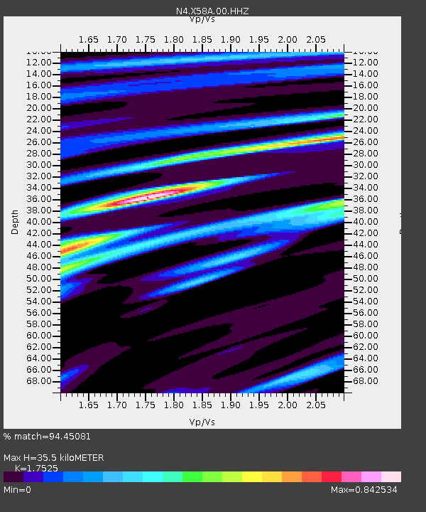
| Estimated Moho Depth: |
35.5 km |
| Estimated Crust Vp/Vs: |
1.75 |
| Assumed Crust Vp: |
6.565 km/s |
| Estimated Crust Vs: |
3.746 km/s |
| Estimated Crust Poisson's Ratio: |
0.26 |
|
| Radial Match: |
94.45081 % |
| Radial Bump: |
289 |
| Transverse Match: |
62.556583 % |
| Transverse Bump: |
400 |
| SOD ConfigId: |
33437571 |
| Insert Time: |
2024-03-28 21:35:41.175 +0000 |
| GWidth: |
2.5 |
| Max Bumps: |
400 |
| Tol: |
0.001 |
|

Signal To Noise
| Channel | StoN | STA | LTA |
| N4:X58A:00:HHZ:20240314T21:16:14.658998Z | 8.183786 | 1.3084583E-6 | 1.5988422E-7 |
| N4:X58A:00:HH1:20240314T21:16:14.658998Z | 1.0180526 | 1.300061E-7 | 1.2770079E-7 |
| N4:X58A:00:HH2:20240314T21:16:14.658998Z | 4.917712 | 8.018181E-7 | 1.6304698E-7 |
| Arrivals |
| Ps | 4.4 SECOND |
| PpPs | 14 SECOND |
| PsPs/PpSs | 18 SECOND |


