You are here: Home > Network List > TX - Texas Seismological Network Stations List
> Station PB23 Bighorn SWD > Earthquake Result Viewer
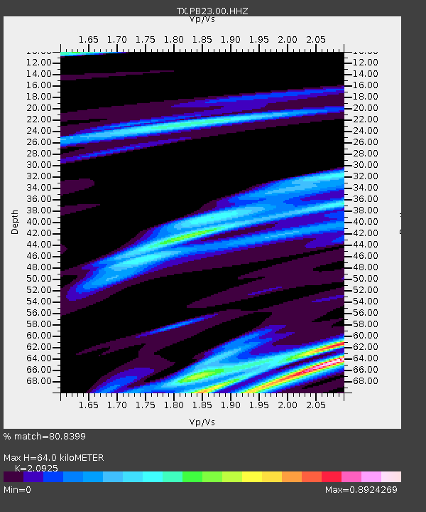
PB23 Bighorn SWD - Earthquake Result Viewer
| Earthquake location: |
Northern Mid-Atlantic Ridge |
| Earthquake latitude/longitude: |
29.8/-42.7 |
| Earthquake time(UTC): |
2024/03/14 (074) 21:10:25 GMT |
| Earthquake Depth: |
10 km |
| Earthquake Magnitude: |
6.0 mww |
| Earthquake Catalog/Contributor: |
NEIC PDE/us |
|
| Network: |
TX Texas Seismological Network |
| Station: |
PB23 Bighorn SWD |
| Lat/Lon: |
31.66 N/104.07 W |
| Elevation: |
1005 m |
|
| Distance: |
52.2 deg |
| Az: |
288.598 deg |
| Baz: |
74.972 deg |
| Ray Param: |
0.06692145 |
| Estimated Moho Depth: |
64.0 km |
| Estimated Crust Vp/Vs: |
2.09 |
| Assumed Crust Vp: |
6.361 km/s |
| Estimated Crust Vs: |
3.04 km/s |
| Estimated Crust Poisson's Ratio: |
0.35 |
|
| Radial Match: |
80.8399 % |
| Radial Bump: |
327 |
| Transverse Match: |
58.069218 % |
| Transverse Bump: |
400 |
| SOD ConfigId: |
33437571 |
| Insert Time: |
2024-03-28 21:45:26.905 +0000 |
| GWidth: |
2.5 |
| Max Bumps: |
400 |
| Tol: |
0.001 |
|

Signal To Noise
| Channel | StoN | STA | LTA |
| TX:PB23:00:HHZ:20240314T21:19:05.106996Z | 4.099198 | 1.0424476E-6 | 2.5430526E-7 |
| TX:PB23:00:HHN:20240314T21:19:05.106996Z | 2.0836134 | 3.8025237E-7 | 1.8249662E-7 |
| TX:PB23:00:HHE:20240314T21:19:05.106996Z | 2.5881884 | 4.650406E-7 | 1.7967804E-7 |
| Arrivals |
| Ps | 12 SECOND |
| PpPs | 30 SECOND |
| PsPs/PpSs | 41 SECOND |


