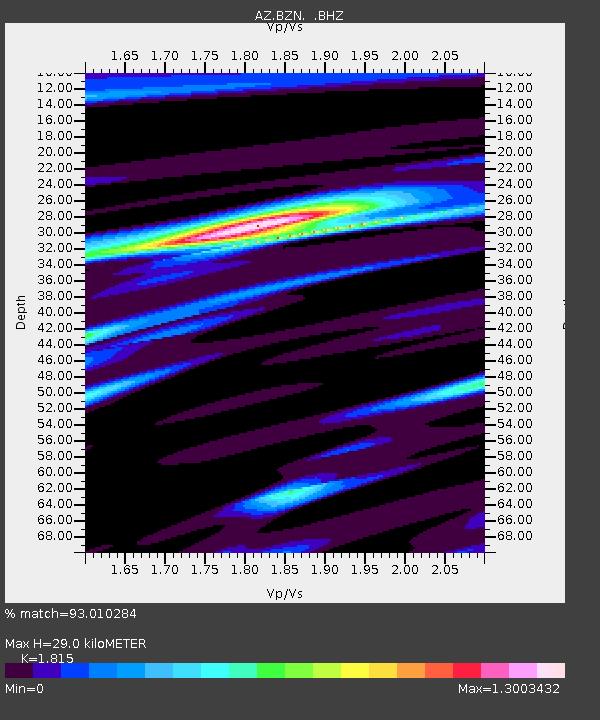
BZN AZ.BZN - Earthquake Result Viewer
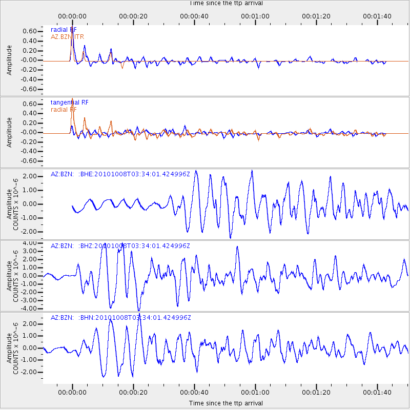
Earthquake location: Andreanof Islands, Aleutian Is.
Earthquake latitude/longitude: 51.4/-175.4
Earthquake time(UTC): 2010/10/08 (281) 03:26:13 GMT
Earthquake Depth: 19 km
Earthquake Magnitude: 6.2 MB, 6.3 MS, 6.4 MW, 6.2 MW
Earthquake Catalog/Contributor: WHDF/NEIC
Network: AZ ANZA Regional Network
Station: BZN AZ.BZN
Lat/Lon: 33.49 N/116.67 W
Elevation: 1301 m
Distance: 45.6 deg
Az: 89.525 deg
Baz: 311.408 deg
Ray Param: 0.0711712
Estimated Moho Depth: 29.0 km
Estimated Crust Vp/Vs: 1.82
Assumed Crust Vp: 6.264 km/s
Estimated Crust Vs: 3.451 km/s
Estimated Crust Poisson's Ratio: 0.28
Radial Match: 93.010284 %
Radial Bump: 313
Transverse Match: 76.605 %
Transverse Bump: 400
SOD ConfigId: 339645
Insert Time: 2011-02-10 07:37:04.609 +0000
GWidth: 2.5
Max Bumps: 400
Tol: 0.001

Signal To Noise

ChannelStoNSTALTA
AZ:BZN: :BHZ:20101008T03:34:01.424996Z4.05777849.5139694E-72.3446253E-7
AZ:BZN: :BHN:20101008T03:34:01.424996Z1.8490163.758615E-72.032765E-7
AZ:BZN: :BHE:20101008T03:34:01.424996Z1.33749643.7918474E-72.8350337E-7
Arrivals
Ps4.0 SECOND
PpPs12 SECOND
PsPs/PpSs16 SECOND