You are here: Home > Network List > US - United States National Seismic Network Stations List
> Station MSO Missoula, Montana, USA > Earthquake Result Viewer
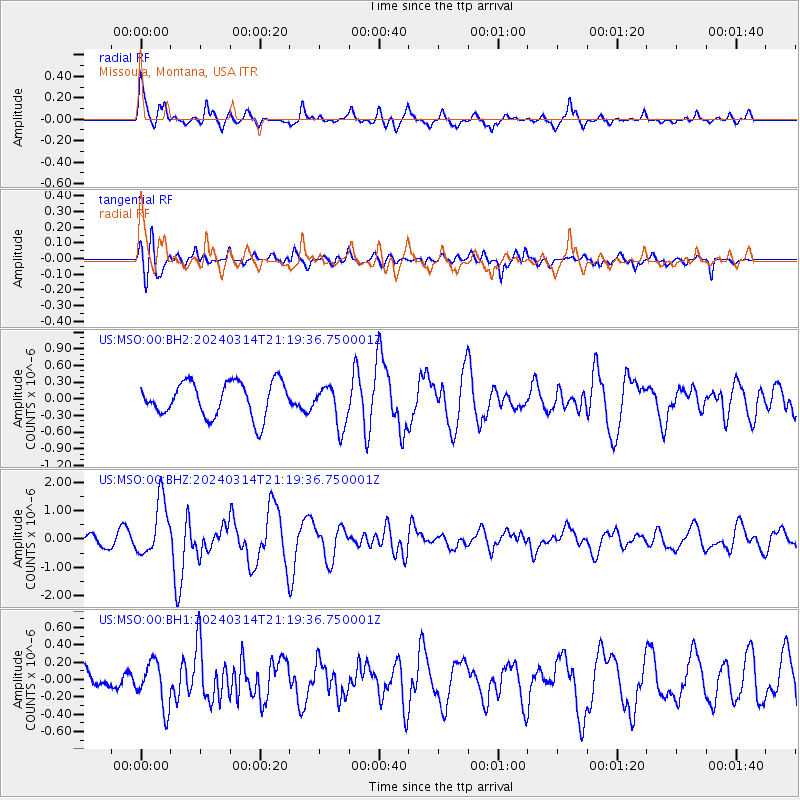
MSO Missoula, Montana, USA - Earthquake Result Viewer
*The percent match for this event was below the threshold and hence no stack was calculated.
| Earthquake location: |
Northern Mid-Atlantic Ridge |
| Earthquake latitude/longitude: |
29.8/-42.7 |
| Earthquake time(UTC): |
2024/03/14 (074) 21:10:25 GMT |
| Earthquake Depth: |
10 km |
| Earthquake Magnitude: |
6.0 mww |
| Earthquake Catalog/Contributor: |
NEIC PDE/us |
|
| Network: |
US United States National Seismic Network |
| Station: |
MSO Missoula, Montana, USA |
| Lat/Lon: |
46.83 N/113.94 W |
| Elevation: |
1264 m |
|
| Distance: |
56.5 deg |
| Az: |
308.789 deg |
| Baz: |
80.544 deg |
| Ray Param: |
$rayparam |
*The percent match for this event was below the threshold and hence was not used in the summary stack. |
|
| Radial Match: |
72.19233 % |
| Radial Bump: |
380 |
| Transverse Match: |
51.923668 % |
| Transverse Bump: |
400 |
| SOD ConfigId: |
33437571 |
| Insert Time: |
2024-03-28 21:48:18.931 +0000 |
| GWidth: |
2.5 |
| Max Bumps: |
400 |
| Tol: |
0.001 |
|
Signal To Noise
| Channel | StoN | STA | LTA |
| US:MSO:00:BHZ:20240314T21:19:36.750001Z | 4.9011264 | 9.857397E-7 | 2.0112513E-7 |
| US:MSO:00:BH1:20240314T21:19:36.750001Z | 1.4362049 | 2.5846418E-7 | 1.799633E-7 |
| US:MSO:00:BH2:20240314T21:19:36.750001Z | 1.1968627 | 3.719124E-7 | 3.1073938E-7 |
| Arrivals |
| Ps | |
| PpPs | |
| PsPs/PpSs | |


