You are here: Home > Network List > AZ - ANZA Regional Network Stations List
> Station CPE Camp Elliot, Miramar, CA, USA > Earthquake Result Viewer
CPE Camp Elliot, Miramar, CA, USA - Earthquake Result Viewer
| Earthquake location: |
Andreanof Islands, Aleutian Is. |
| Earthquake latitude/longitude: |
51.4/-175.4 |
| Earthquake time(UTC): |
2010/10/08 (281) 03:26:13 GMT |
| Earthquake Depth: |
19 km |
| Earthquake Magnitude: |
6.2 MB, 6.3 MS, 6.4 MW, 6.2 MW |
| Earthquake Catalog/Contributor: |
WHDF/NEIC |
|
| Network: |
AZ ANZA Regional Network |
| Station: |
CPE Camp Elliot, Miramar, CA, USA |
| Lat/Lon: |
32.89 N/117.11 W |
| Elevation: |
150 m |
|
| Distance: |
45.7 deg |
| Az: |
90.495 deg |
| Baz: |
311.847 deg |
| Ray Param: |
0.071088985 |
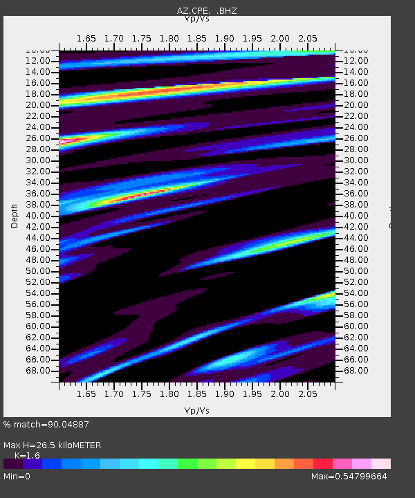
| Estimated Moho Depth: |
26.5 km |
| Estimated Crust Vp/Vs: |
1.60 |
| Assumed Crust Vp: |
6.264 km/s |
| Estimated Crust Vs: |
3.915 km/s |
| Estimated Crust Poisson's Ratio: |
0.18 |
|
| Radial Match: |
90.04887 % |
| Radial Bump: |
352 |
| Transverse Match: |
83.45017 % |
| Transverse Bump: |
400 |
| SOD ConfigId: |
339645 |
| Insert Time: |
2011-02-10 07:37:41.576 +0000 |
| GWidth: |
2.5 |
| Max Bumps: |
400 |
| Tol: |
0.001 |
|

Signal To Noise
| Channel | StoN | STA | LTA |
| AZ:CPE: :BHZ:20101008T03:34:02.419991Z | 1.7592299 | 5.7247854E-7 | 3.2541428E-7 |
| AZ:CPE: :BHN:20101008T03:34:02.419991Z | 1.5665771 | 4.0365373E-7 | 2.5766604E-7 |
| AZ:CPE: :BHE:20101008T03:34:02.419991Z | 1.7828811 | 3.5538937E-7 | 1.993343E-7 |
| Arrivals |
| Ps | 2.7 SECOND |
| PpPs | 10 SECOND |
| PsPs/PpSs | 13 SECOND |


