You are here: Home > Network List > IW - Intermountain West Stations List
> Station MOOW Moose Ponds, Wyoming, USA > Earthquake Result Viewer
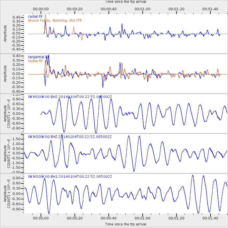
MOOW Moose Ponds, Wyoming, USA - Earthquake Result Viewer
*The percent match for this event was below the threshold and hence no stack was calculated.
| Earthquake location: |
Near Coast Of Northern Chile |
| Earthquake latitude/longitude: |
-20.7/-70.8 |
| Earthquake time(UTC): |
2014/01/04 (004) 00:11:48 GMT |
| Earthquake Depth: |
26 km |
| Earthquake Magnitude: |
5.7 MWW, 5.8 MWB, 5.8 MWC |
| Earthquake Catalog/Contributor: |
NEIC PDE/NEIC COMCAT |
|
| Network: |
IW Intermountain West |
| Station: |
MOOW Moose Ponds, Wyoming, USA |
| Lat/Lon: |
43.75 N/110.74 W |
| Elevation: |
2128 m |
|
| Distance: |
73.8 deg |
| Az: |
331.023 deg |
| Baz: |
141.25 deg |
| Ray Param: |
$rayparam |
*The percent match for this event was below the threshold and hence was not used in the summary stack. |
|
| Radial Match: |
62.92048 % |
| Radial Bump: |
372 |
| Transverse Match: |
59.274956 % |
| Transverse Bump: |
400 |
| SOD ConfigId: |
3390531 |
| Insert Time: |
2019-04-09 21:00:25.153 +0000 |
| GWidth: |
2.5 |
| Max Bumps: |
400 |
| Tol: |
0.001 |
|
Signal To Noise
| Channel | StoN | STA | LTA |
| IW:MOOW:00:BHZ:20140104T00:22:52.065002Z | 1.4128745 | 3.6974507E-7 | 2.6169704E-7 |
| IW:MOOW:00:BH1:20140104T00:22:52.065002Z | 1.9319957 | 6.219307E-7 | 3.2191102E-7 |
| IW:MOOW:00:BH2:20140104T00:22:52.065002Z | 1.2397249 | 6.8156425E-7 | 5.4977056E-7 |
| Arrivals |
| Ps | |
| PpPs | |
| PsPs/PpSs | |


