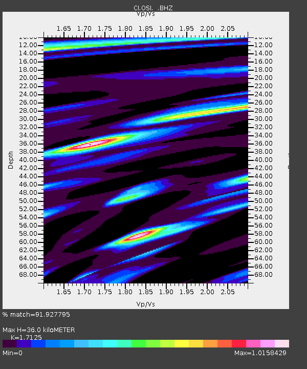
OSI Osito Adit, California, USA - Earthquake Result Viewer
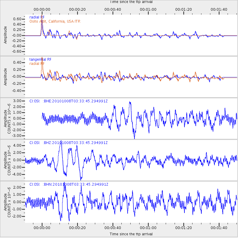
Earthquake location: Andreanof Islands, Aleutian Is.
Earthquake latitude/longitude: 51.4/-175.4
Earthquake time(UTC): 2010/10/08 (281) 03:26:13 GMT
Earthquake Depth: 19 km
Earthquake Magnitude: 6.2 MB, 6.3 MS, 6.4 MW, 6.2 MW
Earthquake Catalog/Contributor: WHDF/NEIC
Network: CI Caltech Regional Seismic Network
Station: OSI Osito Adit, California, USA
Lat/Lon: 34.61 N/118.72 W
Elevation: 706 m
Distance: 43.5 deg
Az: 89.916 deg
Baz: 310.539 deg
Ray Param: 0.07246271
Estimated Moho Depth: 36.0 km
Estimated Crust Vp/Vs: 1.71
Assumed Crust Vp: 6.1 km/s
Estimated Crust Vs: 3.562 km/s
Estimated Crust Poisson's Ratio: 0.24
Radial Match: 91.927795 %
Radial Bump: 400
Transverse Match: 74.48854 %
Transverse Bump: 400
SOD ConfigId: 339645
Insert Time: 2011-02-10 07:40:20.841 +0000
GWidth: 2.5
Max Bumps: 400
Tol: 0.001

Signal To Noise

ChannelStoNSTALTA
CI:OSI: :BHZ:20101008T03:33:45.294991Z2.01057679.3626227E-74.656685E-7
CI:OSI: :BHN:20101008T03:33:45.294991Z1.1180094.6013562E-74.1156704E-7
CI:OSI: :BHE:20101008T03:33:45.294991Z1.04986955.070396E-74.829548E-7
Arrivals
Ps4.5 SECOND
PpPs15 SECOND
PsPs/PpSs20 SECOND