You are here: Home > Network List > CI - Caltech Regional Seismic Network Stations List
> Station RCT Rector, Visalia, CA, USA > Earthquake Result Viewer
RCT Rector, Visalia, CA, USA - Earthquake Result Viewer
| Earthquake location: |
Andreanof Islands, Aleutian Is. |
| Earthquake latitude/longitude: |
51.4/-175.4 |
| Earthquake time(UTC): |
2010/10/08 (281) 03:26:13 GMT |
| Earthquake Depth: |
19 km |
| Earthquake Magnitude: |
6.2 MB, 6.3 MS, 6.4 MW, 6.2 MW |
| Earthquake Catalog/Contributor: |
WHDF/NEIC |
|
| Network: |
CI Caltech Regional Seismic Network |
| Station: |
RCT Rector, Visalia, CA, USA |
| Lat/Lon: |
36.31 N/119.24 W |
| Elevation: |
107 m |
|
| Distance: |
42.1 deg |
| Az: |
88.411 deg |
| Baz: |
309.135 deg |
| Ray Param: |
0.073328294 |
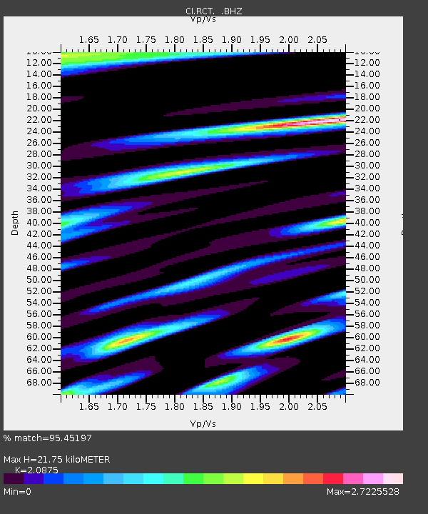
| Estimated Moho Depth: |
21.75 km |
| Estimated Crust Vp/Vs: |
2.09 |
| Assumed Crust Vp: |
6.291 km/s |
| Estimated Crust Vs: |
3.014 km/s |
| Estimated Crust Poisson's Ratio: |
0.35 |
|
| Radial Match: |
95.45197 % |
| Radial Bump: |
400 |
| Transverse Match: |
87.13614 % |
| Transverse Bump: |
400 |
| SOD ConfigId: |
339645 |
| Insert Time: |
2011-02-10 07:41:11.105 +0000 |
| GWidth: |
2.5 |
| Max Bumps: |
400 |
| Tol: |
0.001 |
|

Signal To Noise
| Channel | StoN | STA | LTA |
| CI:RCT: :BHZ:20101008T03:33:33.92701Z | 3.9434085 | 8.5159513E-7 | 2.1595407E-7 |
| CI:RCT: :BHN:20101008T03:33:33.92701Z | 2.5956783 | 6.255272E-7 | 2.4098796E-7 |
| CI:RCT: :BHE:20101008T03:33:33.92701Z | 2.5456638 | 6.5599636E-7 | 2.5769168E-7 |
| Arrivals |
| Ps | 4.0 SECOND |
| PpPs | 10 SECOND |
| PsPs/PpSs | 14 SECOND |


