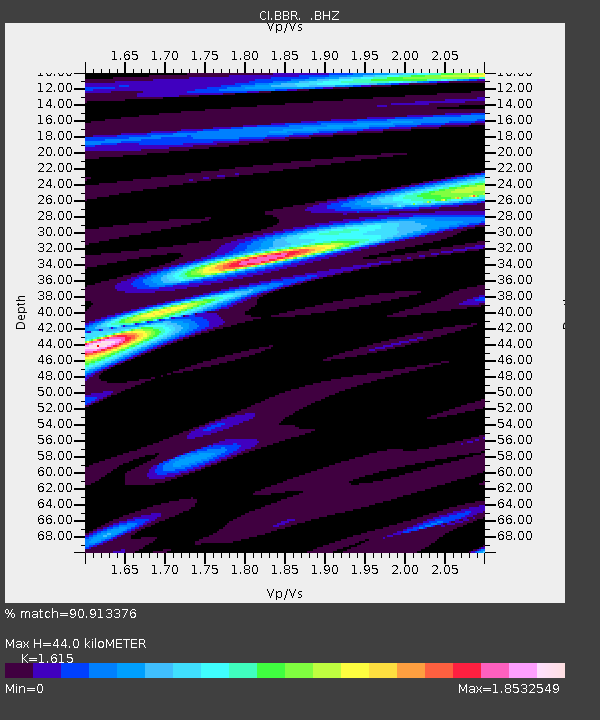
BBR Big Bear Solar Observatory - Earthquake Result Viewer
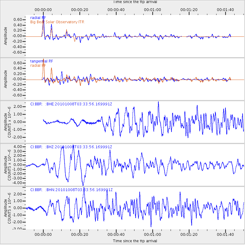
Earthquake location: Andreanof Islands, Aleutian Is.
Earthquake latitude/longitude: 51.4/-175.4
Earthquake time(UTC): 2010/10/08 (281) 03:26:13 GMT
Earthquake Depth: 19 km
Earthquake Magnitude: 6.2 MB, 6.3 MS, 6.4 MW, 6.2 MW
Earthquake Catalog/Contributor: WHDF/NEIC
Network: CI Caltech Regional Seismic Network
Station: BBR Big Bear Solar Observatory
Lat/Lon: 34.26 N/116.92 W
Elevation: 2069 m
Distance: 44.9 deg
Az: 88.905 deg
Baz: 310.83 deg
Ray Param: 0.07160974
Estimated Moho Depth: 44.0 km
Estimated Crust Vp/Vs: 1.62
Assumed Crust Vp: 6.276 km/s
Estimated Crust Vs: 3.886 km/s
Estimated Crust Poisson's Ratio: 0.19
Radial Match: 90.913376 %
Radial Bump: 400
Transverse Match: 76.1044 %
Transverse Bump: 400
SOD ConfigId: 339645
Insert Time: 2011-02-10 07:41:27.414 +0000
GWidth: 2.5
Max Bumps: 400
Tol: 0.001

Signal To Noise

ChannelStoNSTALTA
CI:BBR: :BHZ:20101008T03:33:56.169991Z7.35889057.96213E-71.0819742E-7
CI:BBR: :BHN:20101008T03:33:56.169991Z4.0758255.6928747E-71.3967416E-7
CI:BBR: :BHE:20101008T03:33:56.169991Z2.49419624.845187E-71.9425845E-7
Arrivals
Ps4.6 SECOND
PpPs17 SECOND
PsPs/PpSs22 SECOND