You are here: Home > Network List > CI - Caltech Regional Seismic Network Stations List
> Station FMP Fort MacArthur Park, Pt. Fermin San Pedro, CA, USA > Earthquake Result Viewer
FMP Fort MacArthur Park, Pt. Fermin San Pedro, CA, USA - Earthquake Result Viewer
| Earthquake location: |
Andreanof Islands, Aleutian Is. |
| Earthquake latitude/longitude: |
51.4/-175.4 |
| Earthquake time(UTC): |
2010/10/08 (281) 03:26:13 GMT |
| Earthquake Depth: |
19 km |
| Earthquake Magnitude: |
6.2 MB, 6.3 MS, 6.4 MW, 6.2 MW |
| Earthquake Catalog/Contributor: |
WHDF/NEIC |
|
| Network: |
CI Caltech Regional Seismic Network |
| Station: |
FMP Fort MacArthur Park, Pt. Fermin San Pedro, CA, USA |
| Lat/Lon: |
33.71 N/118.29 W |
| Elevation: |
89 m |
|
| Distance: |
44.4 deg |
| Az: |
90.559 deg |
| Baz: |
311.243 deg |
| Ray Param: |
0.071918294 |
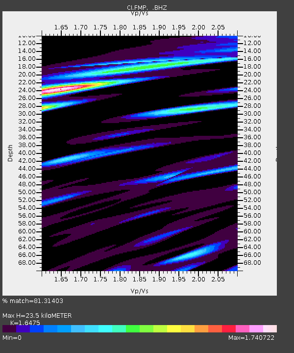
| Estimated Moho Depth: |
23.5 km |
| Estimated Crust Vp/Vs: |
1.65 |
| Assumed Crust Vp: |
6.048 km/s |
| Estimated Crust Vs: |
3.671 km/s |
| Estimated Crust Poisson's Ratio: |
0.21 |
|
| Radial Match: |
81.31403 % |
| Radial Bump: |
400 |
| Transverse Match: |
77.71213 % |
| Transverse Bump: |
400 |
| SOD ConfigId: |
339645 |
| Insert Time: |
2011-02-10 07:41:43.017 +0000 |
| GWidth: |
2.5 |
| Max Bumps: |
400 |
| Tol: |
0.001 |
|

Signal To Noise
| Channel | StoN | STA | LTA |
| CI:FMP: :BHZ:20101008T03:33:52.169991Z | 2.5865786 | 7.790035E-7 | 3.011714E-7 |
| CI:FMP: :BHN:20101008T03:33:52.169991Z | 1.8275408 | 9.978777E-7 | 5.4602214E-7 |
| CI:FMP: :BHE:20101008T03:33:52.169991Z | 1.4791406 | 7.995909E-7 | 5.40578E-7 |
| Arrivals |
| Ps | 2.7 SECOND |
| PpPs | 9.7 SECOND |
| PsPs/PpSs | 12 SECOND |


