You are here: Home > Network List > UW - Pacific Northwest Regional Seismic Network Stations List
> Station HOOD Mt Hood Meadows, OR CREST BB SMO > Earthquake Result Viewer
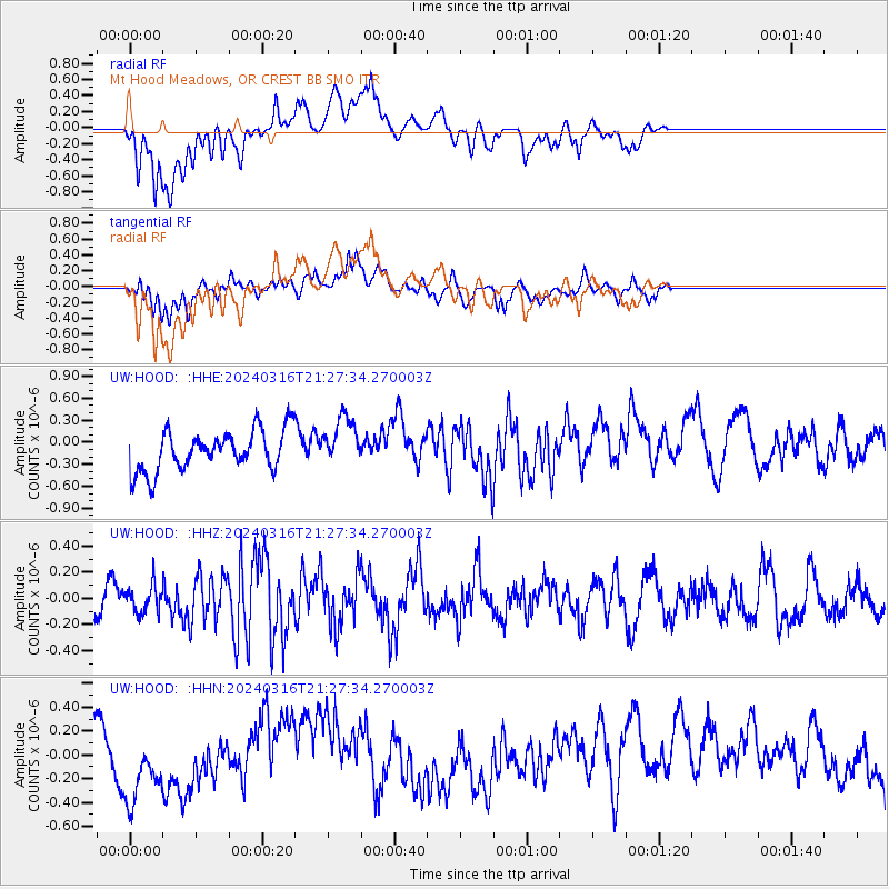
HOOD Mt Hood Meadows, OR CREST BB SMO - Earthquake Result Viewer
*The percent match for this event was below the threshold and hence no stack was calculated.
| Earthquake location: |
Near East Coast Of Honshu, Japan |
| Earthquake latitude/longitude: |
37.1/141.5 |
| Earthquake time(UTC): |
2024/03/16 (076) 21:17:04 GMT |
| Earthquake Depth: |
45 km |
| Earthquake Magnitude: |
5.3 Mww |
| Earthquake Catalog/Contributor: |
NEIC PDE/us |
|
| Network: |
UW Pacific Northwest Regional Seismic Network |
| Station: |
HOOD Mt Hood Meadows, OR CREST BB SMO |
| Lat/Lon: |
45.32 N/121.65 W |
| Elevation: |
1520 m |
|
| Distance: |
69.0 deg |
| Az: |
48.629 deg |
| Baz: |
301.789 deg |
| Ray Param: |
$rayparam |
*The percent match for this event was below the threshold and hence was not used in the summary stack. |
|
| Radial Match: |
50.13734 % |
| Radial Bump: |
400 |
| Transverse Match: |
55.706734 % |
| Transverse Bump: |
400 |
| SOD ConfigId: |
33437571 |
| Insert Time: |
2024-03-30 21:45:09.540 +0000 |
| GWidth: |
2.5 |
| Max Bumps: |
400 |
| Tol: |
0.001 |
|
Signal To Noise
| Channel | StoN | STA | LTA |
| UW:HOOD: :HHZ:20240316T21:27:34.270003Z | 0.4204065 | 1.0650058E-7 | 2.533276E-7 |
| UW:HOOD: :HHN:20240316T21:27:34.270003Z | 1.5546486 | 4.1904477E-7 | 2.6954305E-7 |
| UW:HOOD: :HHE:20240316T21:27:34.270003Z | 1.2448032 | 3.398265E-7 | 2.7299617E-7 |
| Arrivals |
| Ps | |
| PpPs | |
| PsPs/PpSs | |


