You are here: Home > Network List > AZ - ANZA Regional Network Stations List
> Station CRY AZ.CRY > Earthquake Result Viewer
CRY AZ.CRY - Earthquake Result Viewer
| Earthquake location: |
Near Coast Of Peru |
| Earthquake latitude/longitude: |
-13.5/-76.7 |
| Earthquake time(UTC): |
2006/10/20 (293) 10:48:56 GMT |
| Earthquake Depth: |
23 km |
| Earthquake Magnitude: |
5.9 MB, 6.6 MS, 6.7 MW, 6.6 MW |
| Earthquake Catalog/Contributor: |
WHDF/NEIC |
|
| Network: |
AZ ANZA Regional Network |
| Station: |
CRY AZ.CRY |
| Lat/Lon: |
33.57 N/116.74 W |
| Elevation: |
1128 m |
|
| Distance: |
60.4 deg |
| Az: |
321.812 deg |
| Baz: |
133.914 deg |
| Ray Param: |
0.06155019 |
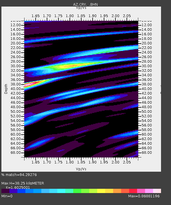
| Estimated Moho Depth: |
38.25 km |
| Estimated Crust Vp/Vs: |
1.60 |
| Assumed Crust Vp: |
6.264 km/s |
| Estimated Crust Vs: |
3.909 km/s |
| Estimated Crust Poisson's Ratio: |
0.18 |
|
| Radial Match: |
94.29276 % |
| Radial Bump: |
314 |
| Transverse Match: |
91.35923 % |
| Transverse Bump: |
400 |
| SOD ConfigId: |
2665 |
| Insert Time: |
2010-02-26 19:00:45.067 +0000 |
| GWidth: |
2.5 |
| Max Bumps: |
400 |
| Tol: |
0.001 |
|
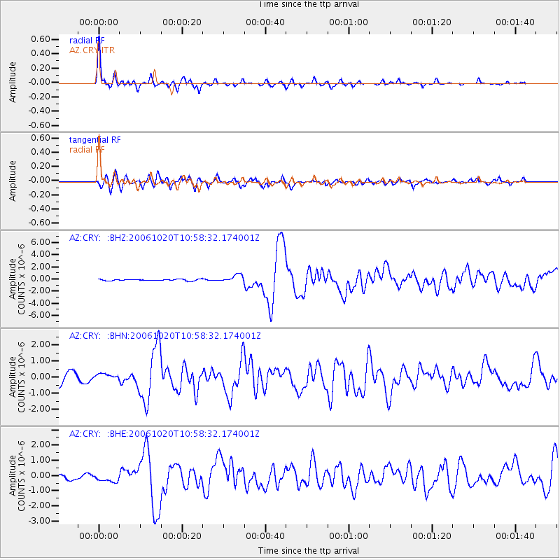
Signal To Noise
| Channel | StoN | STA | LTA |
| AZ:CRY: :BHN:20061020T10:58:32.174001Z | 0.744092 | 2.158997E-7 | 2.901519E-7 |
| AZ:CRY: :BHE:20061020T10:58:32.174001Z | 2.0902753 | 2.917311E-7 | 1.3956587E-7 |
| AZ:CRY: :BHZ:20061020T10:58:32.174001Z | 5.3777676 | 6.2556904E-7 | 1.1632505E-7 |
| Arrivals |
| Ps | 3.9 SECOND |
| PpPs | 15 SECOND |
| PsPs/PpSs | 19 SECOND |


