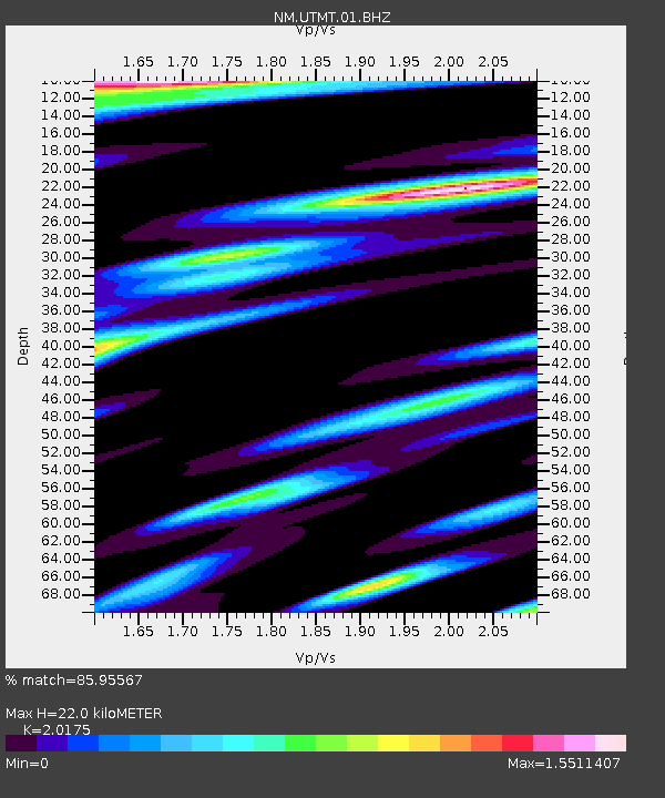
UTMT Martin, TN - Earthquake Result Viewer
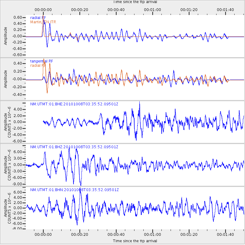
Earthquake location: Andreanof Islands, Aleutian Is.
Earthquake latitude/longitude: 51.4/-175.4
Earthquake time(UTC): 2010/10/08 (281) 03:26:13 GMT
Earthquake Depth: 19 km
Earthquake Magnitude: 6.2 MB, 6.3 MS, 6.4 MW, 6.2 MW
Earthquake Catalog/Contributor: WHDF/NEIC
Network: NM Cooperative New Madrid Seismic Network
Station: UTMT Martin, TN
Lat/Lon: 36.35 N/88.86 W
Elevation: 110 m
Distance: 60.6 deg
Az: 67.641 deg
Baz: 314.108 deg
Ray Param: 0.06139752
Estimated Moho Depth: 22.0 km
Estimated Crust Vp/Vs: 2.02
Assumed Crust Vp: 6.444 km/s
Estimated Crust Vs: 3.194 km/s
Estimated Crust Poisson's Ratio: 0.34
Radial Match: 85.95567 %
Radial Bump: 400
Transverse Match: 76.73185 %
Transverse Bump: 400
SOD ConfigId: 339645
Insert Time: 2011-02-10 07:51:44.715 +0000
GWidth: 2.5
Max Bumps: 400
Tol: 0.001

Signal To Noise

ChannelStoNSTALTA
NM:UTMT:01:BHZ:20101008T03:35:52.09501Z11.3227543.4728255E-63.0671208E-7
NM:UTMT:01:BHN:20101008T03:35:52.09501Z2.0934711.7864818E-68.533587E-7
NM:UTMT:01:BHE:20101008T03:35:52.09501Z2.4647541.8128256E-67.354996E-7
Arrivals
Ps3.6 SECOND
PpPs9.9 SECOND
PsPs/PpSs14 SECOND