You are here: Home > Network List > AK - Alaska Regional Network Stations List
> Station G24K Hadweenzic River, AK, USA > Earthquake Result Viewer
G24K Hadweenzic River, AK, USA - Earthquake Result Viewer
| Earthquake location: |
New Guinea, Papua New Guinea |
| Earthquake latitude/longitude: |
-4.1/143.0 |
| Earthquake time(UTC): |
2024/03/23 (083) 20:22:07 GMT |
| Earthquake Depth: |
64 km |
| Earthquake Magnitude: |
7.0 Mi |
| Earthquake Catalog/Contributor: |
NEIC PDE/pt |
|
| Network: |
AK Alaska Regional Network |
| Station: |
G24K Hadweenzic River, AK, USA |
| Lat/Lon: |
66.70 N/147.48 W |
| Elevation: |
503 m |
|
| Distance: |
85.8 deg |
| Az: |
21.939 deg |
| Baz: |
249.528 deg |
| Ray Param: |
0.0443889 |
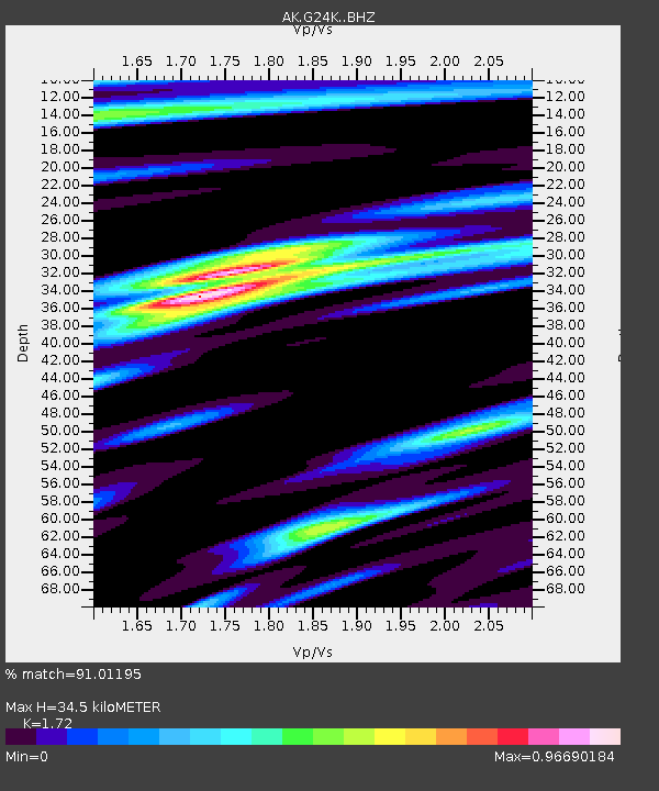
| Estimated Moho Depth: |
34.5 km |
| Estimated Crust Vp/Vs: |
1.72 |
| Assumed Crust Vp: |
6.522 km/s |
| Estimated Crust Vs: |
3.792 km/s |
| Estimated Crust Poisson's Ratio: |
0.24 |
|
| Radial Match: |
91.01195 % |
| Radial Bump: |
400 |
| Transverse Match: |
73.714676 % |
| Transverse Bump: |
400 |
| SOD ConfigId: |
33437571 |
| Insert Time: |
2024-04-06 20:27:50.477 +0000 |
| GWidth: |
2.5 |
| Max Bumps: |
400 |
| Tol: |
0.001 |
|

Signal To Noise
| Channel | StoN | STA | LTA |
| AK:G24K: :BHZ:20240323T20:34:08.359985Z | 11.077887 | 1.9578401E-6 | 1.7673408E-7 |
| AK:G24K: :BHN:20240323T20:34:08.359985Z | 2.2057145 | 2.613844E-7 | 1.1850328E-7 |
| AK:G24K: :BHE:20240323T20:34:08.359985Z | 4.6551876 | 6.0160625E-7 | 1.2923351E-7 |
| Arrivals |
| Ps | 3.9 SECOND |
| PpPs | 14 SECOND |
| PsPs/PpSs | 18 SECOND |


