You are here: Home > Network List > AK - Alaska Regional Network Stations List
> Station JIS Juneau Island, AK, USA > Earthquake Result Viewer
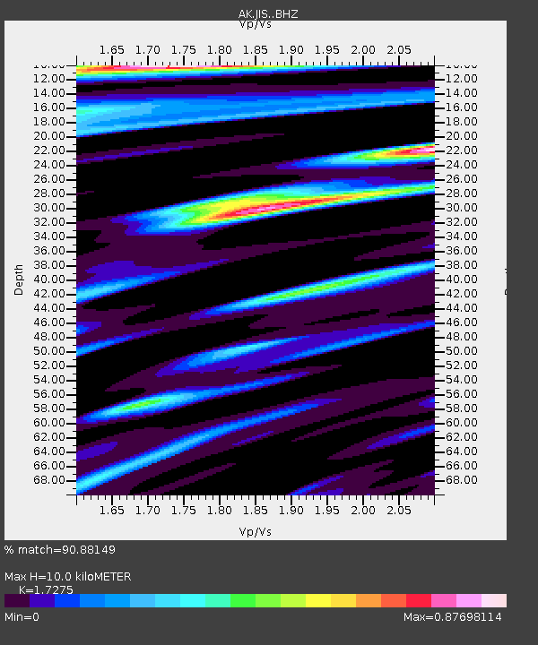
JIS Juneau Island, AK, USA - Earthquake Result Viewer
| Earthquake location: |
New Guinea, Papua New Guinea |
| Earthquake latitude/longitude: |
-4.1/143.0 |
| Earthquake time(UTC): |
2024/03/23 (083) 20:22:07 GMT |
| Earthquake Depth: |
64 km |
| Earthquake Magnitude: |
7.0 Mi |
| Earthquake Catalog/Contributor: |
NEIC PDE/pt |
|
| Network: |
AK Alaska Regional Network |
| Station: |
JIS Juneau Island, AK, USA |
| Lat/Lon: |
58.28 N/134.38 W |
| Elevation: |
10 m |
|
| Distance: |
89.6 deg |
| Az: |
31.601 deg |
| Baz: |
261.554 deg |
| Ray Param: |
0.041732144 |
| Estimated Moho Depth: |
10.0 km |
| Estimated Crust Vp/Vs: |
1.73 |
| Assumed Crust Vp: |
6.566 km/s |
| Estimated Crust Vs: |
3.801 km/s |
| Estimated Crust Poisson's Ratio: |
0.25 |
|
| Radial Match: |
90.88149 % |
| Radial Bump: |
400 |
| Transverse Match: |
78.86901 % |
| Transverse Bump: |
400 |
| SOD ConfigId: |
33437571 |
| Insert Time: |
2024-04-06 20:28:28.047 +0000 |
| GWidth: |
2.5 |
| Max Bumps: |
400 |
| Tol: |
0.001 |
|

Signal To Noise
| Channel | StoN | STA | LTA |
| AK:JIS: :BHZ:20240323T20:34:26.468018Z | 6.431203 | 1.1761446E-6 | 1.8288095E-7 |
| AK:JIS: :BHN:20240323T20:34:26.468018Z | 0.9318202 | 1.3650894E-7 | 1.4649709E-7 |
| AK:JIS: :BHE:20240323T20:34:26.468018Z | 3.9979029 | 3.5229635E-7 | 8.8120295E-8 |
| Arrivals |
| Ps | 1.1 SECOND |
| PpPs | 4.1 SECOND |
| PsPs/PpSs | 5.2 SECOND |


