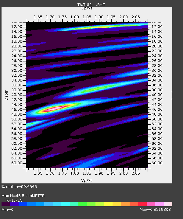
TUL1 Leonard, OK, USA - Earthquake Result Viewer
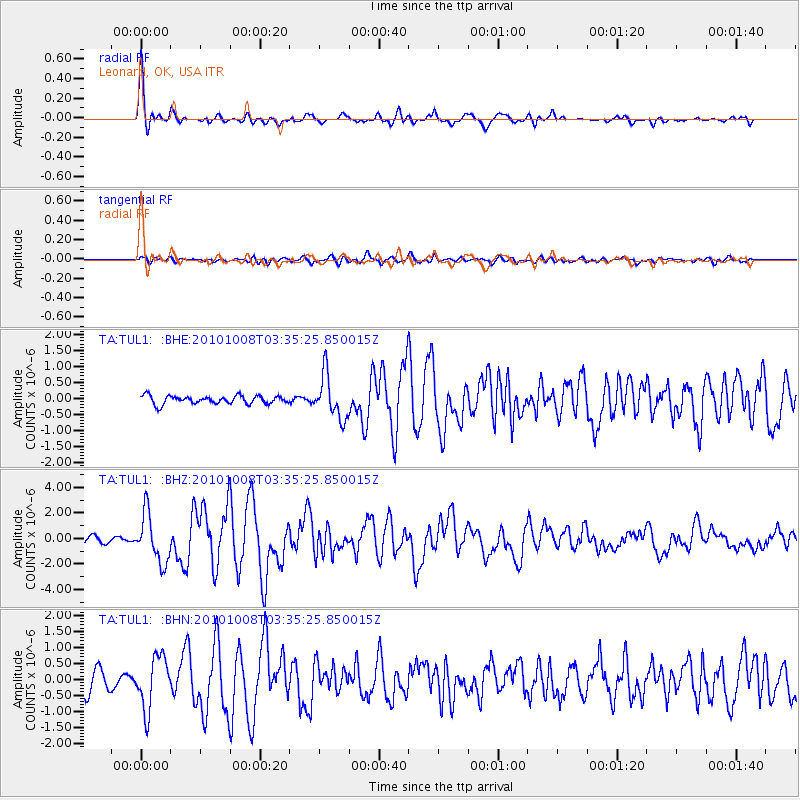
Earthquake location: Andreanof Islands, Aleutian Is.
Earthquake latitude/longitude: 51.4/-175.4
Earthquake time(UTC): 2010/10/08 (281) 03:26:13 GMT
Earthquake Depth: 19 km
Earthquake Magnitude: 6.2 MB, 6.3 MS, 6.4 MW, 6.2 MW
Earthquake Catalog/Contributor: WHDF/NEIC
Network: TA USArray Transportable Network (new EarthScope stations)
Station: TUL1 Leonard, OK, USA
Lat/Lon: 35.91 N/95.79 W
Elevation: 256 m
Distance: 56.8 deg
Az: 72.516 deg
Baz: 312.572 deg
Ray Param: 0.06386348
Estimated Moho Depth: 45.5 km
Estimated Crust Vp/Vs: 1.72
Assumed Crust Vp: 6.498 km/s
Estimated Crust Vs: 3.789 km/s
Estimated Crust Poisson's Ratio: 0.24
Radial Match: 90.6566 %
Radial Bump: 400
Transverse Match: 71.78725 %
Transverse Bump: 400
SOD ConfigId: 339645
Insert Time: 2011-02-10 07:54:55.781 +0000
GWidth: 2.5
Max Bumps: 400
Tol: 0.001

Signal To Noise

ChannelStoNSTALTA
TA:TUL1: :BHZ:20101008T03:35:25.850015Z9.7182451.8893376E-61.944114E-7
TA:TUL1: :BHN:20101008T03:35:25.850015Z3.1621968.1760464E-72.5855596E-7
TA:TUL1: :BHE:20101008T03:35:25.850015Z5.3489896.777989E-71.2671534E-7
Arrivals
Ps5.3 SECOND
PpPs18 SECOND
PsPs/PpSs23 SECOND