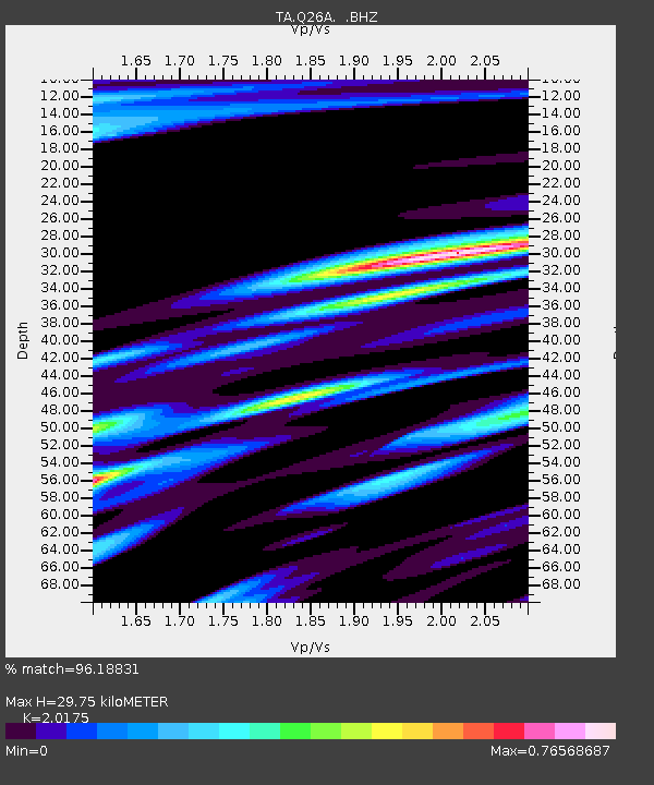
Q26A Hugo, CO, USA - Earthquake Result Viewer

Earthquake location: Andreanof Islands, Aleutian Is.
Earthquake latitude/longitude: 51.4/-175.4
Earthquake time(UTC): 2010/10/08 (281) 03:26:13 GMT
Earthquake Depth: 19 km
Earthquake Magnitude: 6.2 MB, 6.3 MS, 6.4 MW, 6.2 MW
Earthquake Catalog/Contributor: WHDF/NEIC
Network: TA USArray Transportable Network (new EarthScope stations)
Station: Q26A Hugo, CO, USA
Lat/Lon: 38.92 N/103.52 W
Elevation: 1546 m
Distance: 50.2 deg
Az: 74.699 deg
Baz: 309.19 deg
Ray Param: 0.06818424
Estimated Moho Depth: 29.75 km
Estimated Crust Vp/Vs: 2.02
Assumed Crust Vp: 6.242 km/s
Estimated Crust Vs: 3.094 km/s
Estimated Crust Poisson's Ratio: 0.34
Radial Match: 96.18831 %
Radial Bump: 298
Transverse Match: 72.31235 %
Transverse Bump: 400
SOD ConfigId: 339645
Insert Time: 2011-02-10 07:55:36.921 +0000
GWidth: 2.5
Max Bumps: 400
Tol: 0.001

Signal To Noise

ChannelStoNSTALTA
TA:Q26A: :BHZ:20101008T03:34:37.400002Z9.3830432.1730311E-62.315913E-7
TA:Q26A: :BHN:20101008T03:34:37.400002Z2.23397921.1630498E-65.2061796E-7
TA:Q26A: :BHE:20101008T03:34:37.400002Z3.35037951.2605555E-63.7624258E-7
Arrivals
Ps5.1 SECOND
PpPs14 SECOND
PsPs/PpSs19 SECOND