You are here: Home > Network List > AV - Alaska Volcano Observatory Stations List
> Station KARR Katmai Rainbow River, Alaska > Earthquake Result Viewer
KARR Katmai Rainbow River, Alaska - Earthquake Result Viewer
| Earthquake location: |
New Guinea, Papua New Guinea |
| Earthquake latitude/longitude: |
-4.1/143.0 |
| Earthquake time(UTC): |
2024/03/23 (083) 20:22:07 GMT |
| Earthquake Depth: |
64 km |
| Earthquake Magnitude: |
7.0 Mi |
| Earthquake Catalog/Contributor: |
NEIC PDE/pt |
|
| Network: |
AV Alaska Volcano Observatory |
| Station: |
KARR Katmai Rainbow River, Alaska |
| Lat/Lon: |
58.50 N/154.71 W |
| Elevation: |
610 m |
|
| Distance: |
79.5 deg |
| Az: |
28.215 deg |
| Baz: |
243.906 deg |
| Ray Param: |
0.048810292 |
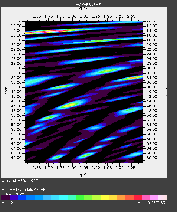
| Estimated Moho Depth: |
14.25 km |
| Estimated Crust Vp/Vs: |
1.68 |
| Assumed Crust Vp: |
6.438 km/s |
| Estimated Crust Vs: |
3.827 km/s |
| Estimated Crust Poisson's Ratio: |
0.23 |
|
| Radial Match: |
85.14057 % |
| Radial Bump: |
400 |
| Transverse Match: |
75.745155 % |
| Transverse Bump: |
400 |
| SOD ConfigId: |
33437571 |
| Insert Time: |
2024-04-06 20:32:47.693 +0000 |
| GWidth: |
2.5 |
| Max Bumps: |
400 |
| Tol: |
0.001 |
|

Signal To Noise
| Channel | StoN | STA | LTA |
| AV:KARR: :BHZ:20240323T20:33:35.640015Z | 6.4244113 | 4.3803498E-6 | 6.8182896E-7 |
| AV:KARR: :BHN:20240323T20:33:35.640015Z | 2.7026925 | 2.1618516E-6 | 7.9988814E-7 |
| AV:KARR: :BHE:20240323T20:33:35.640015Z | 4.4202614 | 2.8743225E-6 | 6.5026074E-7 |
| Arrivals |
| Ps | 1.6 SECOND |
| PpPs | 5.8 SECOND |
| PsPs/PpSs | 7.3 SECOND |


