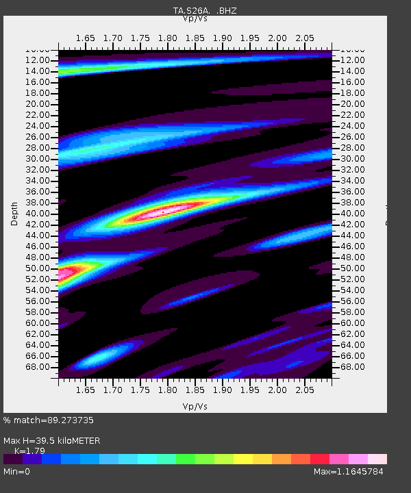
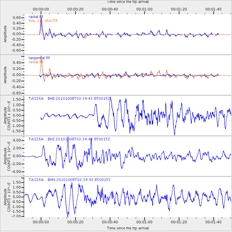
S26A Kim, CO, USA - Earthquake Result Viewer

Earthquake location: Andreanof Islands, Aleutian Is.
Earthquake latitude/longitude: 51.4/-175.4
Earthquake time(UTC): 2010/10/08 (281) 03:26:13 GMT
Earthquake Depth: 19 km
Earthquake Magnitude: 6.2 MB, 6.3 MS, 6.4 MW, 6.2 MW
Earthquake Catalog/Contributor: WHDF/NEIC
Network: TA USArray Transportable Network (new EarthScope stations)
Station: S26A Kim, CO, USA
Lat/Lon: 37.62 N/103.47 W
Elevation: 1394 m
Distance: 51.1 deg
Az: 75.963 deg
Baz: 310.022 deg
Ray Param: 0.06762157
Estimated Moho Depth: 39.5 km
Estimated Crust Vp/Vs: 1.79
Assumed Crust Vp: 6.306 km/s
Estimated Crust Vs: 3.523 km/s
Estimated Crust Poisson's Ratio: 0.27
Radial Match: 89.273735 %
Radial Bump: 400
Transverse Match: 60.186718 %
Transverse Bump: 400
SOD ConfigId: 339645
Insert Time: 2011-02-10 07:55:59.126 +0000
GWidth: 2.5
Max Bumps: 400
Tol: 0.001

Signal To Noise

ChannelStoNSTALTA
TA:S26A: :BHZ:20101008T03:34:43.850015Z9.9537641.4131822E-61.4197465E-7
TA:S26A: :BHN:20101008T03:34:43.850015Z2.34085274.5445825E-71.9414217E-7
TA:S26A: :BHE:20101008T03:34:43.850015Z5.1938526.721464E-71.2941193E-7
Arrivals
Ps5.2 SECOND
PpPs17 SECOND
PsPs/PpSs22 SECOND