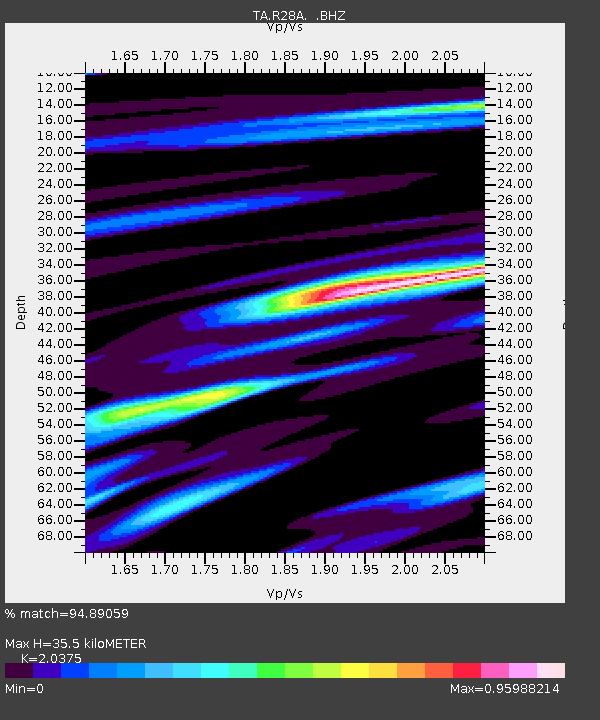
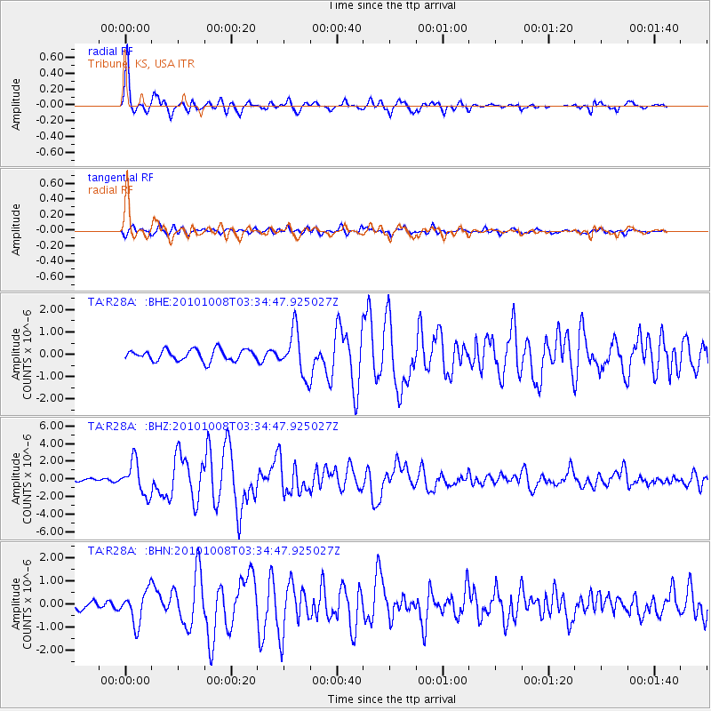
R28A Tribune, KS, USA - Earthquake Result Viewer

Earthquake location: Andreanof Islands, Aleutian Is.
Earthquake latitude/longitude: 51.4/-175.4
Earthquake time(UTC): 2010/10/08 (281) 03:26:13 GMT
Earthquake Depth: 19 km
Earthquake Magnitude: 6.2 MB, 6.3 MS, 6.4 MW, 6.2 MW
Earthquake Catalog/Contributor: WHDF/NEIC
Network: TA USArray Transportable Network (new EarthScope stations)
Station: R28A Tribune, KS, USA
Lat/Lon: 38.34 N/101.81 W
Elevation: 1108 m
Distance: 51.6 deg
Az: 74.177 deg
Baz: 309.924 deg
Ray Param: 0.06727605
Estimated Moho Depth: 35.5 km
Estimated Crust Vp/Vs: 2.04
Assumed Crust Vp: 6.483 km/s
Estimated Crust Vs: 3.182 km/s
Estimated Crust Poisson's Ratio: 0.34
Radial Match: 94.89059 %
Radial Bump: 357
Transverse Match: 75.955 %
Transverse Bump: 400
SOD ConfigId: 339645
Insert Time: 2011-02-10 07:57:44.732 +0000
GWidth: 2.5
Max Bumps: 400
Tol: 0.001

Signal To Noise

ChannelStoNSTALTA
TA:R28A: :BHZ:20101008T03:34:47.925027Z7.7785851.8750173E-62.4104864E-7
TA:R28A: :BHN:20101008T03:34:47.925027Z4.10611877.137399E-71.7382348E-7
TA:R28A: :BHE:20101008T03:34:47.925027Z4.07722661.0054865E-62.466104E-7
Arrivals
Ps6.0 SECOND
PpPs16 SECOND
PsPs/PpSs22 SECOND