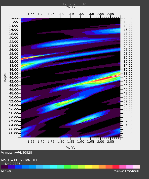
R29A Marienthal, KS, USA - Earthquake Result Viewer

Earthquake location: Andreanof Islands, Aleutian Is.
Earthquake latitude/longitude: 51.4/-175.4
Earthquake time(UTC): 2010/10/08 (281) 03:26:13 GMT
Earthquake Depth: 19 km
Earthquake Magnitude: 6.2 MB, 6.3 MS, 6.4 MW, 6.2 MW
Earthquake Catalog/Contributor: WHDF/NEIC
Network: TA USArray Transportable Network (new EarthScope stations)
Station: R29A Marienthal, KS, USA
Lat/Lon: 38.42 N/101.14 W
Elevation: 957 m
Distance: 52.0 deg
Az: 73.665 deg
Baz: 310.023 deg
Ray Param: 0.06704189
Estimated Moho Depth: 38.75 km
Estimated Crust Vp/Vs: 2.09
Assumed Crust Vp: 6.483 km/s
Estimated Crust Vs: 3.105 km/s
Estimated Crust Poisson's Ratio: 0.35
Radial Match: 96.30828 %
Radial Bump: 280
Transverse Match: 82.91157 %
Transverse Bump: 400
SOD ConfigId: 339645
Insert Time: 2011-02-10 07:58:10.416 +0000
GWidth: 2.5
Max Bumps: 400
Tol: 0.001

Signal To Noise

ChannelStoNSTALTA
TA:R29A: :BHZ:20101008T03:34:50.550027Z19.1763842.2534368E-61.17511036E-7
TA:R29A: :BHN:20101008T03:34:50.550027Z2.98907699.813491E-73.2831176E-7
TA:R29A: :BHE:20101008T03:34:50.550027Z4.0861511.0572608E-62.5874246E-7
Arrivals
Ps6.8 SECOND
PpPs18 SECOND
PsPs/PpSs24 SECOND