You are here: Home > Network List > MM - Myanmar National Seismic Network Stations List
> Station NGU Ngaung U, Myanmar > Earthquake Result Viewer
NGU Ngaung U, Myanmar - Earthquake Result Viewer
| Earthquake location: |
New Guinea, Papua New Guinea |
| Earthquake latitude/longitude: |
-4.1/143.0 |
| Earthquake time(UTC): |
2024/03/23 (083) 20:22:07 GMT |
| Earthquake Depth: |
64 km |
| Earthquake Magnitude: |
7.0 Mi |
| Earthquake Catalog/Contributor: |
NEIC PDE/pt |
|
| Network: |
MM Myanmar National Seismic Network |
| Station: |
NGU Ngaung U, Myanmar |
| Lat/Lon: |
21.21 N/94.92 E |
| Elevation: |
70 m |
|
| Distance: |
53.4 deg |
| Az: |
300.147 deg |
| Baz: |
112.43 deg |
| Ray Param: |
0.0659381 |
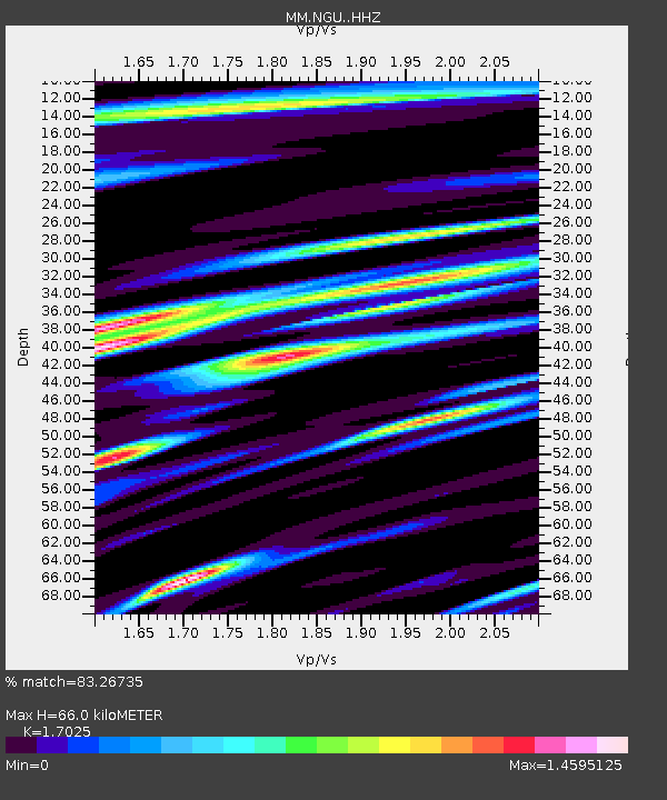
| Estimated Moho Depth: |
66.0 km |
| Estimated Crust Vp/Vs: |
1.70 |
| Assumed Crust Vp: |
6.036 km/s |
| Estimated Crust Vs: |
3.546 km/s |
| Estimated Crust Poisson's Ratio: |
0.24 |
|
| Radial Match: |
83.26735 % |
| Radial Bump: |
400 |
| Transverse Match: |
80.80808 % |
| Transverse Bump: |
400 |
| SOD ConfigId: |
33437571 |
| Insert Time: |
2024-04-06 20:41:20.284 +0000 |
| GWidth: |
2.5 |
| Max Bumps: |
400 |
| Tol: |
0.001 |
|

Signal To Noise
| Channel | StoN | STA | LTA |
| MM:NGU: :HHZ:20240323T20:30:49.840027Z | 14.411847 | 1.8833194E-6 | 1.3067857E-7 |
| MM:NGU: :HHN:20240323T20:30:49.840027Z | 1.6843181 | 2.1306784E-7 | 1.2650094E-7 |
| MM:NGU: :HHE:20240323T20:30:49.840027Z | 2.98908 | 3.9258472E-7 | 1.3133965E-7 |
| Arrivals |
| Ps | 8.1 SECOND |
| PpPs | 28 SECOND |
| PsPs/PpSs | 36 SECOND |


