You are here: Home > Network List > TM - Thai Seismic Monitoring Network Stations List
> Station SURA Don Sak, Surat Thani > Earthquake Result Viewer
SURA Don Sak, Surat Thani - Earthquake Result Viewer
| Earthquake location: |
New Guinea, Papua New Guinea |
| Earthquake latitude/longitude: |
-4.1/143.0 |
| Earthquake time(UTC): |
2024/03/23 (083) 20:22:07 GMT |
| Earthquake Depth: |
64 km |
| Earthquake Magnitude: |
7.0 Mi |
| Earthquake Catalog/Contributor: |
NEIC PDE/pt |
|
| Network: |
TM Thai Seismic Monitoring Network |
| Station: |
SURA Don Sak, Surat Thani |
| Lat/Lon: |
9.17 N/99.63 E |
| Elevation: |
18 m |
|
| Distance: |
45.2 deg |
| Az: |
287.149 deg |
| Baz: |
105.149 deg |
| Ray Param: |
0.07123538 |
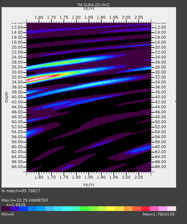
| Estimated Moho Depth: |
32.25 km |
| Estimated Crust Vp/Vs: |
1.65 |
| Assumed Crust Vp: |
6.468 km/s |
| Estimated Crust Vs: |
3.914 km/s |
| Estimated Crust Poisson's Ratio: |
0.21 |
|
| Radial Match: |
95.78927 % |
| Radial Bump: |
386 |
| Transverse Match: |
86.64065 % |
| Transverse Bump: |
400 |
| SOD ConfigId: |
33437571 |
| Insert Time: |
2024-04-06 20:43:46.481 +0000 |
| GWidth: |
2.5 |
| Max Bumps: |
400 |
| Tol: |
0.001 |
|

Signal To Noise
| Channel | StoN | STA | LTA |
| TM:SURA:00:HHZ:20240323T20:29:47.359985Z | 8.158437 | 6.81709E-7 | 8.355878E-8 |
| TM:SURA:00:HHN:20240323T20:29:47.359985Z | 1.0002247 | 1.2873042E-7 | 1.287015E-7 |
| TM:SURA:00:HHE:20240323T20:29:47.359985Z | 2.6737716 | 3.434566E-7 | 1.2845398E-7 |
| Arrivals |
| Ps | 3.5 SECOND |
| PpPs | 12 SECOND |
| PsPs/PpSs | 16 SECOND |


