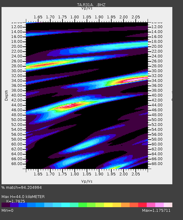
R31A Burdett, KS, USA - Earthquake Result Viewer
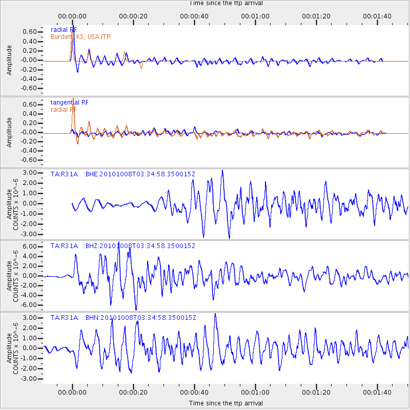
Earthquake location: Andreanof Islands, Aleutian Is.
Earthquake latitude/longitude: 51.4/-175.4
Earthquake time(UTC): 2010/10/08 (281) 03:26:13 GMT
Earthquake Depth: 19 km
Earthquake Magnitude: 6.2 MB, 6.3 MS, 6.4 MW, 6.2 MW
Earthquake Catalog/Contributor: WHDF/NEIC
Network: TA USArray Transportable Network (new EarthScope stations)
Station: R31A Burdett, KS, USA
Lat/Lon: 38.29 N/99.53 W
Elevation: 667 m
Distance: 53.0 deg
Az: 72.764 deg
Baz: 310.47 deg
Ray Param: 0.06635658
Estimated Moho Depth: 44.0 km
Estimated Crust Vp/Vs: 1.76
Assumed Crust Vp: 6.483 km/s
Estimated Crust Vs: 3.678 km/s
Estimated Crust Poisson's Ratio: 0.26
Radial Match: 94.204994 %
Radial Bump: 336
Transverse Match: 83.21187 %
Transverse Bump: 400
SOD ConfigId: 339645
Insert Time: 2011-02-10 07:59:01.347 +0000
GWidth: 2.5
Max Bumps: 400
Tol: 0.001

Signal To Noise

ChannelStoNSTALTA
TA:R31A: :BHZ:20101008T03:34:58.350015Z7.5612982.0516381E-62.7133413E-7
TA:R31A: :BHN:20101008T03:34:58.350015Z3.0386599.486061E-73.1217917E-7
TA:R31A: :BHE:20101008T03:34:58.350015Z2.30824336.4144064E-72.7789125E-7
Arrivals
Ps5.5 SECOND
PpPs18 SECOND
PsPs/PpSs23 SECOND