You are here: Home > Network List > TA - USArray Transportable Network (new EarthScope stations) Stations List
> Station M30A Dale-Ortello Valley, Anselmo, NE, USA > Earthquake Result Viewer
M30A Dale-Ortello Valley, Anselmo, NE, USA - Earthquake Result Viewer
| Earthquake location: |
Andreanof Islands, Aleutian Is. |
| Earthquake latitude/longitude: |
51.4/-175.4 |
| Earthquake time(UTC): |
2010/10/08 (281) 03:26:13 GMT |
| Earthquake Depth: |
19 km |
| Earthquake Magnitude: |
6.2 MB, 6.3 MS, 6.4 MW, 6.2 MW |
| Earthquake Catalog/Contributor: |
WHDF/NEIC |
|
| Network: |
TA USArray Transportable Network (new EarthScope stations) |
| Station: |
M30A Dale-Ortello Valley, Anselmo, NE, USA |
| Lat/Lon: |
41.54 N/99.87 W |
| Elevation: |
853 m |
|
| Distance: |
50.8 deg |
| Az: |
69.794 deg |
| Baz: |
308.416 deg |
| Ray Param: |
0.067819506 |
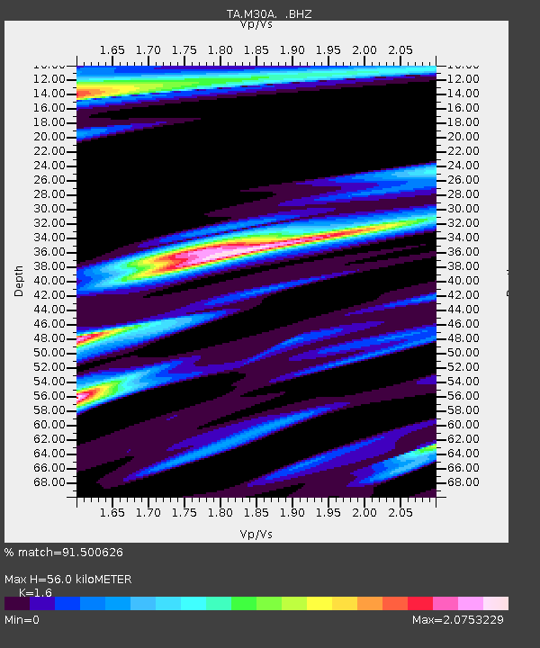
| Estimated Moho Depth: |
56.0 km |
| Estimated Crust Vp/Vs: |
1.60 |
| Assumed Crust Vp: |
6.53 km/s |
| Estimated Crust Vs: |
4.082 km/s |
| Estimated Crust Poisson's Ratio: |
0.18 |
|
| Radial Match: |
91.500626 % |
| Radial Bump: |
315 |
| Transverse Match: |
89.67521 % |
| Transverse Bump: |
393 |
| SOD ConfigId: |
339645 |
| Insert Time: |
2011-02-10 07:59:12.780 +0000 |
| GWidth: |
2.5 |
| Max Bumps: |
400 |
| Tol: |
0.001 |
|

Signal To Noise
| Channel | StoN | STA | LTA |
| TA:M30A: :BHZ:20101008T03:34:41.475015Z | 7.8981023 | 2.7872338E-6 | 3.5289918E-7 |
| TA:M30A: :BHN:20101008T03:34:41.475015Z | 1.533226 | 1.7544444E-6 | 1.1442829E-6 |
| TA:M30A: :BHE:20101008T03:34:41.475015Z | 2.4477499 | 2.2948038E-6 | 9.375157E-7 |
| Arrivals |
| Ps | 5.5 SECOND |
| PpPs | 21 SECOND |
| PsPs/PpSs | 26 SECOND |


