You are here: Home > Network List > TA - USArray Transportable Network (new EarthScope stations) Stations List
> Station N28A Pribbeno Ranch, Imperial, NE, USA > Earthquake Result Viewer
N28A Pribbeno Ranch, Imperial, NE, USA - Earthquake Result Viewer
| Earthquake location: |
Andreanof Islands, Aleutian Is. |
| Earthquake latitude/longitude: |
51.4/-175.4 |
| Earthquake time(UTC): |
2010/10/08 (281) 03:26:13 GMT |
| Earthquake Depth: |
19 km |
| Earthquake Magnitude: |
6.2 MB, 6.3 MS, 6.4 MW, 6.2 MW |
| Earthquake Catalog/Contributor: |
WHDF/NEIC |
|
| Network: |
TA USArray Transportable Network (new EarthScope stations) |
| Station: |
N28A Pribbeno Ranch, Imperial, NE, USA |
| Lat/Lon: |
40.69 N/101.54 W |
| Elevation: |
1009 m |
|
| Distance: |
50.3 deg |
| Az: |
71.671 deg |
| Baz: |
308.516 deg |
| Ray Param: |
0.06812964 |
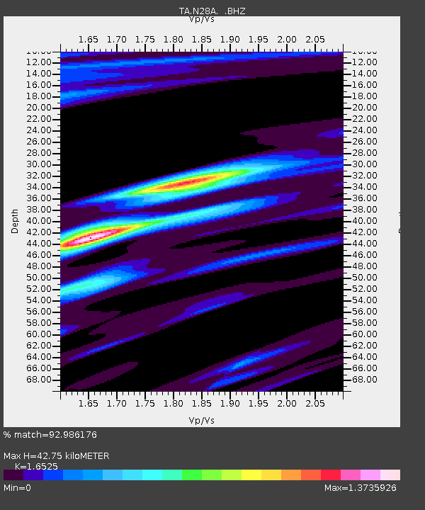
| Estimated Moho Depth: |
42.75 km |
| Estimated Crust Vp/Vs: |
1.65 |
| Assumed Crust Vp: |
6.483 km/s |
| Estimated Crust Vs: |
3.923 km/s |
| Estimated Crust Poisson's Ratio: |
0.21 |
|
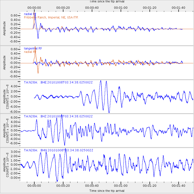
| Radial Match: |
92.986176 % |
| Radial Bump: |
270 |
| Transverse Match: |
78.38169 % |
| Transverse Bump: |
334 |
| SOD ConfigId: |
339645 |
| Insert Time: |
2011-02-10 07:59:32.931 +0000 |
| GWidth: |
2.5 |
| Max Bumps: |
400 |
| Tol: |
0.001 |
|
Signal To Noise
| Channel | StoN | STA | LTA |
| TA:N28A: :BHZ:20101008T03:34:38.025002Z | 12.315234 | 2.6032355E-6 | 2.1138337E-7 |
| TA:N28A: :BHN:20101008T03:34:38.025002Z | 4.065388 | 1.6251483E-6 | 3.997523E-7 |
| TA:N28A: :BHE:20101008T03:34:38.025002Z | 4.089562 | 1.6305473E-6 | 3.9870952E-7 |
| Arrivals |
| Ps | 4.6 SECOND |
| PpPs | 16 SECOND |
| PsPs/PpSs | 21 SECOND |


