You are here: Home > Network List > TA - USArray Transportable Network (new EarthScope stations) Stations List
> Station J28A Allard Ranch, Norris, SD, USA > Earthquake Result Viewer
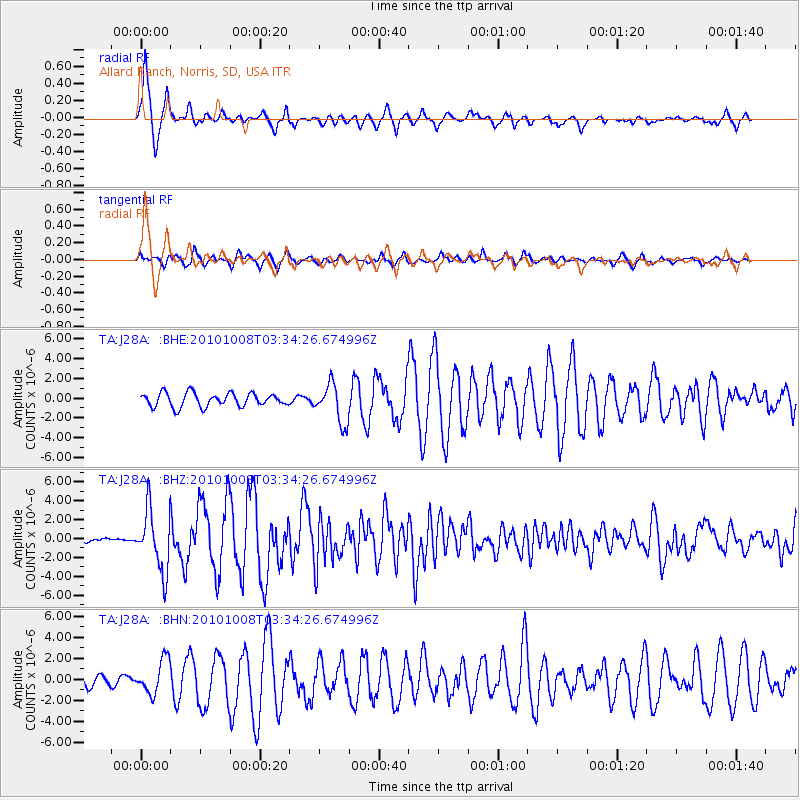
J28A Allard Ranch, Norris, SD, USA - Earthquake Result Viewer
| Earthquake location: |
Andreanof Islands, Aleutian Is. |
| Earthquake latitude/longitude: |
51.4/-175.4 |
| Earthquake time(UTC): |
2010/10/08 (281) 03:26:13 GMT |
| Earthquake Depth: |
19 km |
| Earthquake Magnitude: |
6.2 MB, 6.3 MS, 6.4 MW, 6.2 MW |
| Earthquake Catalog/Contributor: |
WHDF/NEIC |
|
| Network: |
TA USArray Transportable Network (new EarthScope stations) |
| Station: |
J28A Allard Ranch, Norris, SD, USA |
| Lat/Lon: |
43.42 N/101.24 W |
| Elevation: |
835 m |
|
| Distance: |
48.8 deg |
| Az: |
68.643 deg |
| Baz: |
306.755 deg |
| Ray Param: |
0.06909295 |
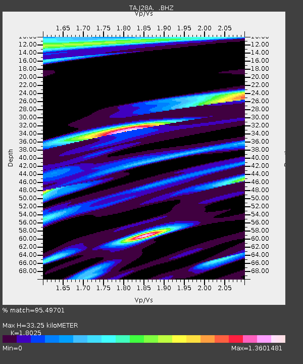
| Estimated Moho Depth: |
33.25 km |
| Estimated Crust Vp/Vs: |
1.80 |
| Assumed Crust Vp: |
6.483 km/s |
| Estimated Crust Vs: |
3.596 km/s |
| Estimated Crust Poisson's Ratio: |
0.28 |
|
| Radial Match: |
95.49701 % |
| Radial Bump: |
329 |
| Transverse Match: |
79.56139 % |
| Transverse Bump: |
400 |
| SOD ConfigId: |
339645 |
| Insert Time: |
2011-02-10 07:59:56.477 +0000 |
| GWidth: |
2.5 |
| Max Bumps: |
400 |
| Tol: |
0.001 |
|
Signal To Noise
| Channel | StoN | STA | LTA |
| TA:J28A: :BHZ:20101008T03:34:26.674996Z | 15.199314 | 3.1951274E-6 | 2.1021523E-7 |
| TA:J28A: :BHN:20101008T03:34:26.674996Z | 2.5245922 | 1.6177494E-6 | 6.4079626E-7 |
| TA:J28A: :BHE:20101008T03:34:26.674996Z | 2.8563879 | 1.9587708E-6 | 6.85751E-7 |
| Arrivals |
| Ps | 4.4 SECOND |
| PpPs | 14 SECOND |
| PsPs/PpSs | 18 SECOND |


