You are here: Home > Network List > TA - USArray Transportable Network (new EarthScope stations) Stations List
> Station K28A Ten Mile Ranch, Cody, NE, USA > Earthquake Result Viewer
K28A Ten Mile Ranch, Cody, NE, USA - Earthquake Result Viewer
| Earthquake location: |
Andreanof Islands, Aleutian Is. |
| Earthquake latitude/longitude: |
51.4/-175.4 |
| Earthquake time(UTC): |
2010/10/08 (281) 03:26:13 GMT |
| Earthquake Depth: |
19 km |
| Earthquake Magnitude: |
6.2 MB, 6.3 MS, 6.4 MW, 6.2 MW |
| Earthquake Catalog/Contributor: |
WHDF/NEIC |
|
| Network: |
TA USArray Transportable Network (new EarthScope stations) |
| Station: |
K28A Ten Mile Ranch, Cody, NE, USA |
| Lat/Lon: |
42.71 N/101.37 W |
| Elevation: |
986 m |
|
| Distance: |
49.2 deg |
| Az: |
69.471 deg |
| Baz: |
307.209 deg |
| Ray Param: |
0.06885848 |
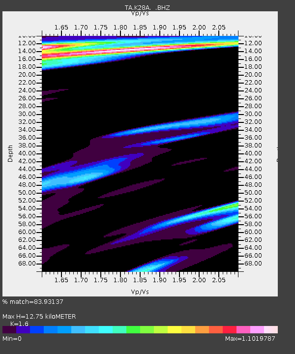
| Estimated Moho Depth: |
12.75 km |
| Estimated Crust Vp/Vs: |
1.60 |
| Assumed Crust Vp: |
6.483 km/s |
| Estimated Crust Vs: |
4.052 km/s |
| Estimated Crust Poisson's Ratio: |
0.18 |
|
| Radial Match: |
83.93137 % |
| Radial Bump: |
391 |
| Transverse Match: |
65.89048 % |
| Transverse Bump: |
386 |
| SOD ConfigId: |
339645 |
| Insert Time: |
2011-02-10 08:00:01.160 +0000 |
| GWidth: |
2.5 |
| Max Bumps: |
400 |
| Tol: |
0.001 |
|

Signal To Noise
| Channel | StoN | STA | LTA |
| TA:K28A: :BHZ:20101008T03:34:29.350015Z | 8.69473 | 2.5594231E-6 | 2.943649E-7 |
| TA:K28A: :BHN:20101008T03:34:29.350015Z | 1.3549278 | 1.3142685E-6 | 9.699916E-7 |
| TA:K28A: :BHE:20101008T03:34:29.350015Z | 0.9526474 | 8.339129E-7 | 8.753637E-7 |
| Arrivals |
| Ps | 1.3 SECOND |
| PpPs | 4.8 SECOND |
| PsPs/PpSs | 6.0 SECOND |


