You are here: Home > Network List > TA - USArray Transportable Network (new EarthScope stations) Stations List
> Station L28A Connealy Angus Ranch, Whitman, NE, USA > Earthquake Result Viewer
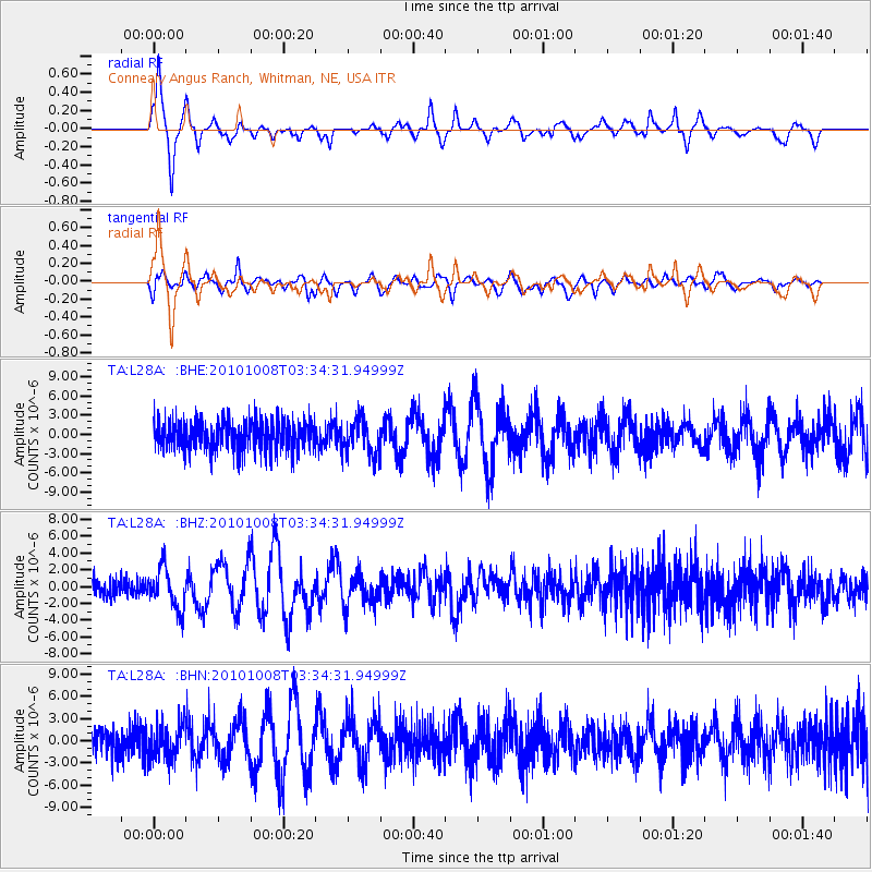
L28A Connealy Angus Ranch, Whitman, NE, USA - Earthquake Result Viewer
| Earthquake location: |
Andreanof Islands, Aleutian Is. |
| Earthquake latitude/longitude: |
51.4/-175.4 |
| Earthquake time(UTC): |
2010/10/08 (281) 03:26:13 GMT |
| Earthquake Depth: |
19 km |
| Earthquake Magnitude: |
6.2 MB, 6.3 MS, 6.4 MW, 6.2 MW |
| Earthquake Catalog/Contributor: |
WHDF/NEIC |
|
| Network: |
TA USArray Transportable Network (new EarthScope stations) |
| Station: |
L28A Connealy Angus Ranch, Whitman, NE, USA |
| Lat/Lon: |
42.01 N/101.52 W |
| Elevation: |
1155 m |
|
| Distance: |
49.5 deg |
| Az: |
70.301 deg |
| Baz: |
307.647 deg |
| Ray Param: |
0.06864195 |
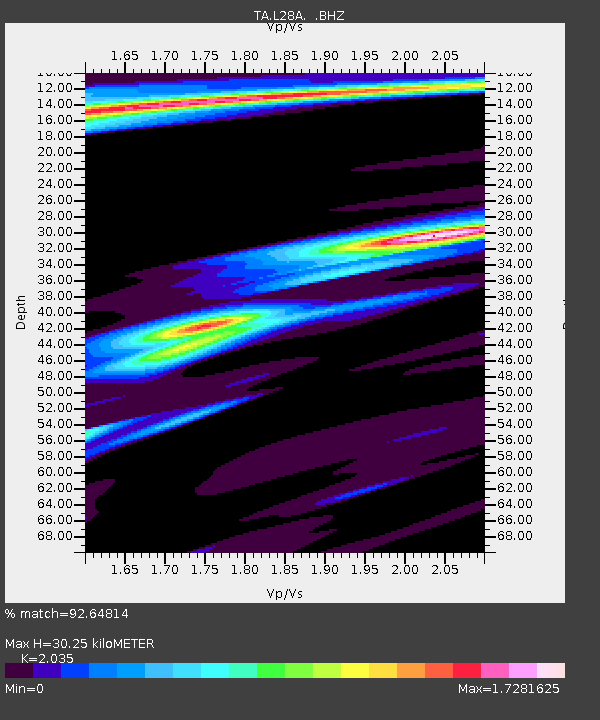
| Estimated Moho Depth: |
30.25 km |
| Estimated Crust Vp/Vs: |
2.04 |
| Assumed Crust Vp: |
6.483 km/s |
| Estimated Crust Vs: |
3.186 km/s |
| Estimated Crust Poisson's Ratio: |
0.34 |
|
| Radial Match: |
92.64814 % |
| Radial Bump: |
291 |
| Transverse Match: |
72.696785 % |
| Transverse Bump: |
400 |
| SOD ConfigId: |
339645 |
| Insert Time: |
2011-02-10 08:00:12.525 +0000 |
| GWidth: |
2.5 |
| Max Bumps: |
400 |
| Tol: |
0.001 |
|
Signal To Noise
| Channel | StoN | STA | LTA |
| TA:L28A: :BHZ:20101008T03:34:31.94999Z | 3.0251203 | 2.405622E-6 | 7.9521527E-7 |
| TA:L28A: :BHN:20101008T03:34:31.94999Z | 1.278354 | 2.3123553E-6 | 1.8088534E-6 |
| TA:L28A: :BHE:20101008T03:34:31.94999Z | 1.1691126 | 2.7103529E-6 | 2.3182995E-6 |
| Arrivals |
| Ps | 5.1 SECOND |
| PpPs | 13 SECOND |
| PsPs/PpSs | 19 SECOND |


