You are here: Home > Network List > TA - USArray Transportable Network (new EarthScope stations) Stations List
> Station J25A Sunshine Ranch, Edgemont, SD, USA > Earthquake Result Viewer
J25A Sunshine Ranch, Edgemont, SD, USA - Earthquake Result Viewer
| Earthquake location: |
Andreanof Islands, Aleutian Is. |
| Earthquake latitude/longitude: |
51.4/-175.4 |
| Earthquake time(UTC): |
2010/10/08 (281) 03:26:13 GMT |
| Earthquake Depth: |
19 km |
| Earthquake Magnitude: |
6.2 MB, 6.3 MS, 6.4 MW, 6.2 MW |
| Earthquake Catalog/Contributor: |
WHDF/NEIC |
|
| Network: |
TA USArray Transportable Network (new EarthScope stations) |
| Station: |
J25A Sunshine Ranch, Edgemont, SD, USA |
| Lat/Lon: |
43.39 N/103.80 W |
| Elevation: |
1220 m |
|
| Distance: |
47.3 deg |
| Az: |
70.171 deg |
| Baz: |
306.018 deg |
| Ray Param: |
0.07004486 |
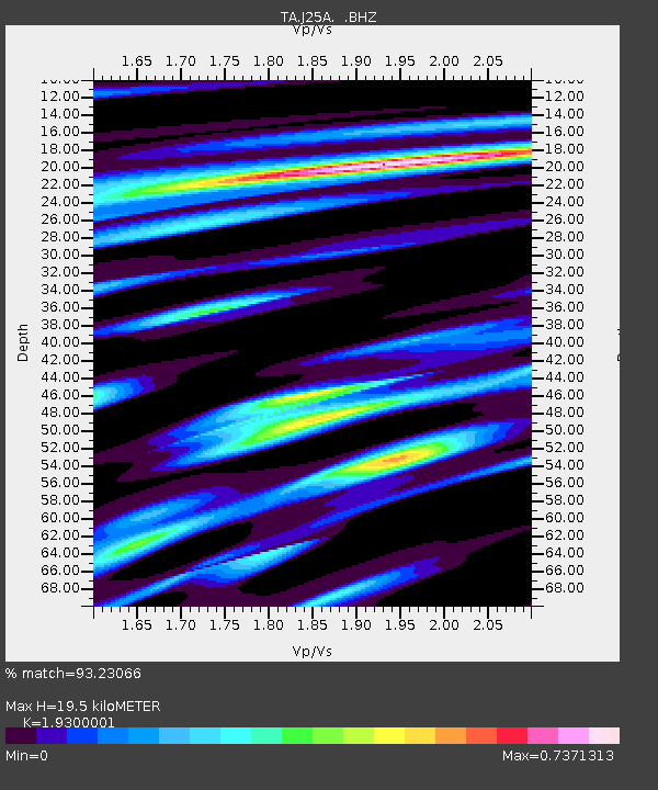
| Estimated Moho Depth: |
19.5 km |
| Estimated Crust Vp/Vs: |
1.93 |
| Assumed Crust Vp: |
6.483 km/s |
| Estimated Crust Vs: |
3.359 km/s |
| Estimated Crust Poisson's Ratio: |
0.32 |
|
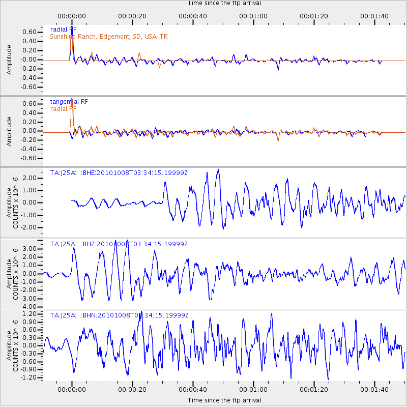
| Radial Match: |
93.23066 % |
| Radial Bump: |
400 |
| Transverse Match: |
79.70102 % |
| Transverse Bump: |
400 |
| SOD ConfigId: |
339645 |
| Insert Time: |
2011-02-10 08:00:19.855 +0000 |
| GWidth: |
2.5 |
| Max Bumps: |
400 |
| Tol: |
0.001 |
|
Signal To Noise
| Channel | StoN | STA | LTA |
| TA:J25A: :BHZ:20101008T03:34:15.19999Z | 15.11196 | 1.8155025E-6 | 1.2013679E-7 |
| TA:J25A: :BHN:20101008T03:34:15.19999Z | 3.5932791 | 4.956258E-7 | 1.3793134E-7 |
| TA:J25A: :BHE:20101008T03:34:15.19999Z | 4.4316115 | 8.8150716E-7 | 1.9891345E-7 |
| Arrivals |
| Ps | 3.0 SECOND |
| PpPs | 8.3 SECOND |
| PsPs/PpSs | 11 SECOND |


