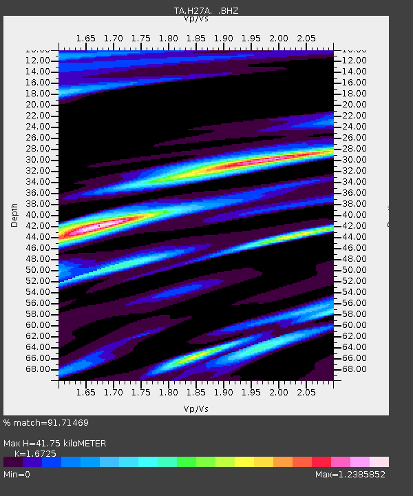
H27A Howes, SD, USA - Earthquake Result Viewer

Earthquake location: Andreanof Islands, Aleutian Is.
Earthquake latitude/longitude: 51.4/-175.4
Earthquake time(UTC): 2010/10/08 (281) 03:26:13 GMT
Earthquake Depth: 19 km
Earthquake Magnitude: 6.2 MB, 6.3 MS, 6.4 MW, 6.2 MW
Earthquake Catalog/Contributor: WHDF/NEIC
Network: TA USArray Transportable Network (new EarthScope stations)
Station: H27A Howes, SD, USA
Lat/Lon: 44.63 N/102.08 W
Elevation: 748 m
Distance: 47.6 deg
Az: 67.815 deg
Baz: 305.62 deg
Ray Param: 0.06986161
Estimated Moho Depth: 41.75 km
Estimated Crust Vp/Vs: 1.67
Assumed Crust Vp: 6.242 km/s
Estimated Crust Vs: 3.732 km/s
Estimated Crust Poisson's Ratio: 0.22
Radial Match: 91.71469 %
Radial Bump: 333
Transverse Match: 84.46707 %
Transverse Bump: 400
SOD ConfigId: 339645
Insert Time: 2011-02-10 08:00:32.075 +0000
GWidth: 2.5
Max Bumps: 400
Tol: 0.001

Signal To Noise

ChannelStoNSTALTA
TA:H27A: :BHZ:20101008T03:34:17.400002Z12.6158182.852164E-62.260784E-7
TA:H27A: :BHN:20101008T03:34:17.400002Z2.39304071.3080255E-65.4659563E-7
TA:H27A: :BHE:20101008T03:34:17.400002Z4.99033162.0677246E-64.1434615E-7
Arrivals
Ps4.8 SECOND
PpPs17 SECOND
PsPs/PpSs22 SECOND