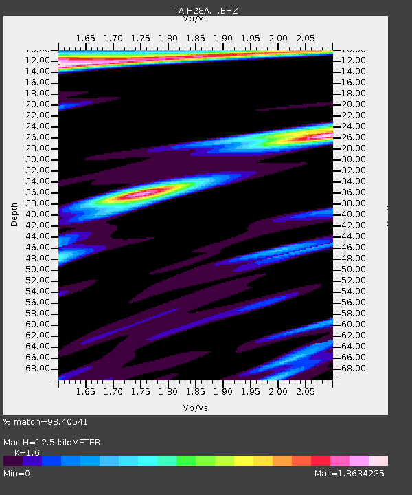
H28A Mission Ridge, SD, USA - Earthquake Result Viewer
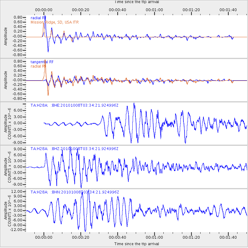
Earthquake location: Andreanof Islands, Aleutian Is.
Earthquake latitude/longitude: 51.4/-175.4
Earthquake time(UTC): 2010/10/08 (281) 03:26:13 GMT
Earthquake Depth: 19 km
Earthquake Magnitude: 6.2 MB, 6.3 MS, 6.4 MW, 6.2 MW
Earthquake Catalog/Contributor: WHDF/NEIC
Network: TA USArray Transportable Network (new EarthScope stations)
Station: H28A Mission Ridge, SD, USA
Lat/Lon: 44.68 N/101.02 W
Elevation: 642 m
Distance: 48.2 deg
Az: 67.175 deg
Baz: 305.931 deg
Ray Param: 0.06949639
Estimated Moho Depth: 12.5 km
Estimated Crust Vp/Vs: 1.60
Assumed Crust Vp: 6.53 km/s
Estimated Crust Vs: 4.082 km/s
Estimated Crust Poisson's Ratio: 0.18
Radial Match: 98.40541 %
Radial Bump: 256
Transverse Match: 96.36884 %
Transverse Bump: 330
SOD ConfigId: 339645
Insert Time: 2011-02-10 08:00:54.544 +0000
GWidth: 2.5
Max Bumps: 400
Tol: 0.001

Signal To Noise

ChannelStoNSTALTA
TA:H28A: :BHZ:20101008T03:34:21.924996Z23.1568224.3502655E-61.8786108E-7
TA:H28A: :BHN:20101008T03:34:21.924996Z5.8440282.711449E-64.639692E-7
TA:H28A: :BHE:20101008T03:34:21.924996Z6.38758852.867044E-64.4884607E-7
Arrivals
Ps1.2 SECOND
PpPs4.6 SECOND
PsPs/PpSs5.9 SECOND